Breadcrumb
Bureau of Economic Geology Publications
Title | Publication Year Sort ascending | Abstract | Author | Publisher | |
---|---|---|---|---|---|
![]() |
Quantitative palynology of the Paleocene Lower Wilcox Group of Texas: taxonomy, biostratigraphy, and paleoecology | 2025 | 
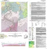
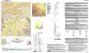
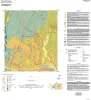
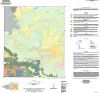
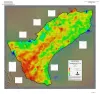
Palynological analysis of four onshore wells (Edmond Olinick No 1, Jerome Olinick No 16, Lawrence Keseling No 1, Moczygemba VT No 11) in the Paleocene Lower Wilcox Group of Texas in the United States has yielded abundant and diverse palynomorph taxa from Paleocene shallow marine deltaic paleoenvi |
Smith, Vann, Moscardelli, Lorena, Bord, D., Lorente, M.A., Olariu, M.I. | Bureau of Economic Geology |
![]() |
Carbon-nots to the Rescue! | 2025 | The Carbon-nots to the Rescue comic book was initially designed as supplemental material to help middle school science teachers explain new concepts within revised state educational standards for Texas students, known as |
van der Kolk, D.A., Mastrangelo, F.M., Hovorka, S.D., Tran, V.H., Luciano, A.K. | Bureau of Economic Geology |
![]() |
Annual Report of the Bureau of Economic Geology 2024 | 2025 | In 1909, the Bureau of Economic Geology (Bureau) was created with the mission to increase the understanding of geology and geological resources, and stimulate the economy in Texas. |
University of Texas at Austin, Bureau of Economic Geology | Bureau of Economic Geology |
![]() |
Regional and Local Variability in Lowstand Valley Fill and Deltaic Deposits in the Tannehill Sandstone (Cisco Group), Eastern Shelf of the Permian Basin | 2024 | Lowstand valley fill and shelf-edge deltaic deposits in the Tannehill sandstone (Wolfcampian Cisco Group) in the Eastern Shelf of the Permian Basin are major targets for oil and gas exploration. |
Ambrose, W.A., Hentz, T.F., Rogers, H., Carr, D.L. | Bureau of Economic Geology |
![]() |
Geothermal Resources, South Texas | 2024 | A series of two 1:500,000 scale maps showing the Geothermal resources of South Texas. |
Andrews, J.R. | Bureau of Economic Geology |
![]() |
Geologic map of the Norton Mesa quadrangle, Texas | 2024 | Elliott, Brent A. | Bureau of Economic Geology | |
![]() |
Geologic map of the Decros Point quadrangle, Texas Gulf Of Mexico Coast | 2024 | Aerial imagery used in this study included 0.6- and 1.0-m pixel, natural color, National Agriculture Imagery Program digital imagery photographed in 2020 and 2022. |
Morris, J.N., Paine, J.G. | Bureau of Economic Geology |
![]() |
Geologic map of the Montopolis quadrangle, Travis County, Texas | 2023 | This map presents a graphic means for engineers, planners, and property owners to recognize and cope with the changes in substrate properties across this fault zone. Fault displacement has created a profound and abrupt change in land-use capabilities in this area. |
Woodruff, C.M., Jr., Morris, J.N. | Bureau of Economic Geology |
![]() |
Northern Gulf of Mexico Sandstone Reservoir-Quality Database (GOMRQ): Multiple Data Types for Evaluating Reservoir-Quality Risk | 2023 | Loucks, R.G., Dutton, S.P. | Bureau of Economic Geology | |
![]() |
Airborne And Ground Surveys of the April 2023 Daisetta Sinkhole, Liberty County, Texas | 2023 | On Sunday, April 2, 2023, a sinkhole formed on the northwestern flank of the Hull salt dome in the city of Daisetta, Texas (fig 1). |
Paine, J.G., Andrews, J.R., Morris, J.N., Saylam, K., Kyle, J.R. | Bureau of Economic Geology |