|
GeoGulf Transactions Volume 75 (2026) Baton Rouge |
|
2026 |
Gulf Coast Association of Geological Societies |
|
Terminology and Reference Guide for Mobile Shales |
Soto, J.I. |
2025 |
Selected Reports |
|
Quantitative palynology of the Paleocene Lower Wilcox Group of Texas: taxonomy, biostratigraphy, and paleoecology |
Smith, Vann, Moscardelli, Lorena, Bord, D., Lorente, M.A., Olariu, M.I. |
2025 |
Report of Investigations |
|
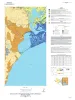
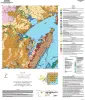
Geologic map of the Port Ingleside quadrangle, Texas Gulf coast |
Paine, J.G., Caudle, T.L., Morris, J.N., Grunau, B.A. |
2025 |
Open-File Map |
|
Geologic map of the Cove and Umbrella Point quadrangles, Texas Gulf coast |
Caudle, T.L., Paine, J.G. |
2025 |
Open-File Map |
|
Geologic map of the Mesquite Bay area, Texas Gulf Coast |
Paine, J.G., Caudle, T.L., Grunau, B.A., Morris, J.N. |
2025 |
Open-File Map |
|
Geologic map of the Taft area, Texas Gulf Coast |
Paine, J.G., Morris, J.N., Grunau, B.A. |
2025 |
Open-File Map |
|
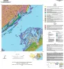
Geologic Map of Trinity Bay, Texas Gulf coast |
Caudle, T.L., Paine, J.G. |
2025 |
Open-File Map |
|
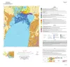
Geologic map of the Copano Bay area, Texas Gulf Coast |
Paine, J.G., Collins, E.W., Costard, L., Grunau, B.A., Morris, J.N., Caudle, T.L. |
2025 |
Open-File Map |
|
GeoGulf Transactions Volume 74 (2025) Nacogdoches, Texas |
|
2025 |
Gulf Coast Association of Geological Societies |
|
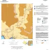
Bedrock Geologic Map of the Fly Gap Quadrangle, Mason County, Texas |
Hunt, B.B., Helper, M.A., Droddy, Jr., M.J. |
2025 |
Open-File Map |
|
Geologic Map of the Gorman Falls Quadrangle, San Saba, Lampasas and Burnet Counties, Texas |
Hunt, B.B., Helper, M.A. |
2025 |
Open-File Map |
|
Geologic Map of the Toyahvale Quadrangle, Jeff Davis and Reeves Counties, Texas |
Hunt, B.B., Helper, M.A., Horne, E.A., Hennings, P.H., Rhoden, E. |
2025 |
Open-File Map |
|
Geologic map of the Austin East quadrangle, Travis County, Texas |
Morris, J.N., Woodruff, C.M., Jr., Grunau, B.A. |
2025 |
Open-File Map |
|
Geologic map of the Diablo Canyon East quadrangle, Hudspeth County, Texas |
Elliott, Brent A., Short, S.R., Ugurhan, M. |
2025 |
Open-File Map |
|
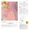
Geothermal Resources, Onshore Gulf Coast Texas |
Andrews, J.R. |
2025 |
Open-File Map |
|
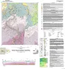
Simplified Geologic Map of Texas with Geologic Time Scale |
Werner, C.W., Mastrangelo, F.M. |
2025 |
Thematic Maps |
|
Annual Report of the Bureau of Economic Geology 2024 |
University of Texas at Austin, Bureau of Economic Geology |
2025 |
Annual Reports |
|
Carbon-nots to the Rescue! |
van der Kolk, D.A., Mastrangelo, F.M., Hovorka, S.D., Tran, V.H., Luciano, A.K. |
2025 |
Coloring and Comic Books |
|
GCAGS Journal, Volume 14 (2025) |
Loucks, R.G., Brown, Alton, Zahm, C.K. |
2025 |
Gulf Coast Association of Geological Societies |