Bureau of Economic Geology Publications
| Title | Publication Year Sort ascending | Abstract | Author | Publisher | |
|---|---|---|---|---|---|
|
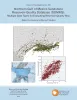
Factors Influencing Rock Strength and Fluid Flow at the Basement–Sediment Interface from Field and Core-Based Observations, Llano Uplift, Texas | 2023 | The hydromechanical properties of the uppermost basement and of the basement–sediment interface influence multiple geologic processes of societal relevance, including the flow of groundwater; the accumulation of hydrocarbons, economic minerals, and geothermal resources; and the response of seismo |
Callahan, O.A., Eichhubl, Peter, Kyle, J.R. | Bureau of Economic Geology |
|
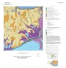
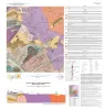
Geologic map of a Portion of the Southeastern Llano Uplift, Burnet, Llano, and Blanco Counties Texas | 2023 | Helper, M.A., Hunt, B.B., Barnes, V.E. | Bureau of Economic Geology | |
|
The Geologic Basement of Texas: A Volume in Honor of Peter T. Flawn | 2023 | This volume is still in preparation. 6 of the 9 chapters are available digitally -- links provided below: |
Bureau of Economic Geology | |
|
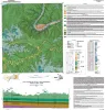
Geologic map of the Montopolis quadrangle, Travis County, Texas | 2023 | This map presents a graphic means for engineers, planners, and property owners to recognize and cope with the changes in substrate properties across this fault zone. Fault displacement has created a profound and abrupt change in land-use capabilities in this area. |
Woodruff, C.M., Jr., Morris, J.N. | Bureau of Economic Geology |
|
Northern Gulf of Mexico Sandstone Reservoir-Quality Database (GOMRQ): Multiple Data Types for Evaluating Reservoir-Quality Risk | 2023 | Loucks, R.G., Dutton, S.P. | Bureau of Economic Geology | |
|
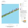
Geologic map of the Palacios NE quadrangle, Texas Gulf of Mexico Coast | 2022 | Paine, J.G., Costard, L. | Bureau of Economic Geology | |
|
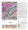
Geologic Map of the Bee Cave Quadrangle, Travis County, Texas | 2022 | Geology illustrated on this map and accompanying geologic map database was revised using field, aerial-photograph, and LiDAR interpretations following a review of previous work on the area’s geology. |
Hunt, B.B., Andrews, J.R. | Bureau of Economic Geology |
|
Geologic map of the Palacios SE quadrangle, Texas Gulf of Mexico Coast | 2022 | Paine, J.G., Costard, L., Caudle, T.L. | Bureau of Economic Geology | |
|
Geologic map of the Mason Quadrangle, Mason County, Texas | 2022 | Hunt, B.B., Johnson, B., Helper, M.A., Droxler, A. | Bureau of Economic Geology | |
|
Geologic map of the Turtle Creek Quadrangle, Mason County, Texas | 2022 | Hunt, B.B., Johnson, B., Helper, M.A., Droxler, A. | Bureau of Economic Geology |