Publication Search

Publications by Hunt, B.B.

Title Publication Year Sort ascending Abstract Author Series Publisher
Geologic map of the Panther Creek quadrangle, Mason County, Texas Geologic map of the Panther Creek quadrangle, Mason County, Texas 2023 Hunt, B.B. Open-File Map Bureau of Economic Geology
Geologic map of the Monument Mountain SE quadrangle, Mason County, Texas Geologic map of the Monument Mountain SE quadrangle, Mason County, Texas 2023 Hunt, B.B. Open-File Map Bureau of Economic Geology
Geologic map of the Dolan Springs quadrangle, Val Verde County, Texas Geologic map of the Dolan Springs quadrangle, Val Verde County, Texas 2023 Hunt, B.B., Andrews, J.R., Paine, J.G. Open-File Map Bureau of Economic Geology
Geologic map of a Portion of the Southeastern Llano Uplift, Burnet, Llano, and Blanco Counties Texas Geologic map of a Portion of the Southeastern Llano Uplift, Burnet, Llano, and Blanco Counties Texas 2023 Helper, M., Hunt, B.B., Barnes, V.E. Open-File Map Bureau of Economic Geology
Geologic map of the Mason Quadrangle, Mason County, Texas Geologic map of the Mason Quadrangle, Mason County, Texas 2022 Hunt, B.B., Johnson, B., Helper, M., Droxler, A. Open-File Map Bureau of Economic Geology
Geologic map of the Turtle Creek Quadrangle, Mason County, Texas Geologic map of the Turtle Creek Quadrangle, Mason County, Texas 2022 Hunt, B.B., Johnson, B., Helper, M., Droxler, A. Open-File Map Bureau of Economic Geology
Bee Cave Quadrangle Map Thumbnail Geologic Map of the Bee Cave Quadrangle, Travis County, Texas 2022

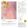
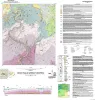
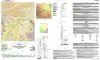
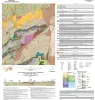
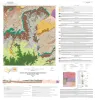
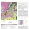
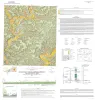
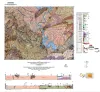
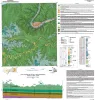
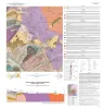
Geology illustrated on this map and accompanying geologic map database was revised using field, aerial-photograph, and LiDAR interpretations following a review of previous work on the area’s geology.

Hunt, B.B., Andrews, J.R. Open-File Map Bureau of Economic Geology
Geologic map of the Grit quadrangle, Mason County, Texas Geologic map of the Grit quadrangle, Mason County, Texas 2021 Hunt, B.B., Johnson, B., Helper, M. Open-File Map Bureau of Economic Geology
Geologic map of the Pedernales Falls, Johnson City, Howell Mountain, and Round Mountain quadrangles, Blanco County, Texas Geologic map of the Pedernales Falls, Johnson City, Howell Mountain, and Round Mountain quadrangles, Blanco County, Texas 2021 Hunt, B.B., Woodruff, C.M., Jr., Barnes, V.E. Open-File Map Bureau of Economic Geology
Geology at the Crossroads--Big Bend Ranch State Park, Presidio and Brewster Counties, Texas Geology at the Crossroads--Big Bend Ranch State Park, Presidio and Brewster Counties, Texas 2019 Hall, Blain R., Dickerson, P.W., Hunt, B.B. Austin Geological Society Austin Geological Society