Bureau of Economic Geology Publications
| Title | Publication Year Sort ascending | Abstract | Author | Publisher | |
|---|---|---|---|---|---|
|
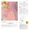
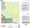
Bedrock Geologic Map of the Fly Gap Quadrangle, Mason County, Texas | 2025 | Hunt, B.B., Helper, M.A., Droddy, Jr., M.J. | Bureau of Economic Geology | |
|
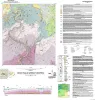
Geologic Map of the Gorman Falls Quadrangle, San Saba, Lampasas and Burnet Counties, Texas | 2025 | Hunt, B.B., Helper, M.A. | Bureau of Economic Geology | |
|
Geologic Map of the Toyahvale Quadrangle, Jeff Davis and Reeves Counties, Texas | 2025 | Hunt, B.B., Helper, M.A., Horne, E.A., Hennings, P.H., Rhoden, E. | Bureau of Economic Geology | |
|
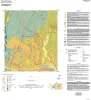
Geologic map of the Austin East quadrangle, Travis County, Texas | 2025 | Morris, J.N., Woodruff, C.M., Jr., Grunau, B.A. | Bureau of Economic Geology | |
|
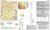
Geologic map of the Diablo Canyon East quadrangle, Hudspeth County, Texas | 2025 | Elliott, Brent A., Short, S.R., Ugurhan, M. | Bureau of Economic Geology | |
|
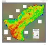
Geothermal Resources, Onshore Gulf Coast Texas | 2025 | A series of two 1:900,000 scale maps showing the Geothermal resources of Onshore Gulf Coast Texas. |
Andrews, J.R. | Bureau of Economic Geology |
|
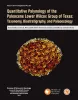
Quantitative palynology of the Paleocene Lower Wilcox Group of Texas: taxonomy, biostratigraphy, and paleoecology | 2025 | Palynological analysis of four onshore wells (Edmond Olinick No 1, Jerome Olinick No 16, Lawrence Keseling No 1, Moczygemba VT No 11) in the Paleocene Lower Wilcox Group of Texas in the United States has yielded abundant and diverse palynomorph taxa from Paleocene shallow marine deltaic paleoenvi |
Smith, Vann, Moscardelli, Lorena, Bord, D., Lorente, M.A., Olariu, M.I. | Bureau of Economic Geology |
|
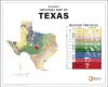
Simplified Geologic Map of Texas with Geologic Time Scale | 2025 | This full-color poster shows a simplified geologic map of Texas created for classroom learning and general interest. The map highlights the major rock types and geologic regions of the state, helping viewers see how Texas was formed over hundreds of millions of years. |
Werner, C.W., Mastrangelo, F.M. | Bureau of Economic Geology |
|
Carbon-nots to the Rescue! | 2025 | The Carbon-nots to the Rescue comic book was initially designed as supplemental material to help middle school science teachers explain new concepts within revised state educational standards for Texas students, known as Texas Essential Knowledge and Skills (TEKS). |
van der Kolk, D.A., Mastrangelo, F.M., Hovorka, S.D., Tran, V.H., Luciano, A.K. | Bureau of Economic Geology |
|
GCAGS Journal, Volume 14 (2025) | 2025 | During the Cretaceous Late Albian Stage, extensive carbonate deposition occurred across Texas. Many of these carbonates have been well studied, leading to numerous publications. This investigation focuses on the less-studied Upper Albian Fort Lancaster Formation in the Trans-Pecos region. |
Loucks, R.G., Brown, Alton, Zahm, C.K. | Bureau of Economic Geology |