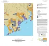
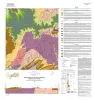
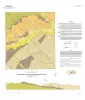
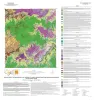
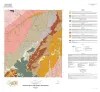
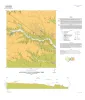
Publication Search

Bureau of Economic Geology Publications

Title Publication Year Sort ascending Abstract Author Publisher
Geologic map of the Lytton Springs quadrangle, Texas Geologic map of the Lytton Springs quadrangle, Texas 2021 Woodruff, C.M., Jr., Costard, L. Bureau of Economic Geology
A systematic approach to identifying hydrocarbon sweet spots using integrated seismic multiattribute, wireline-log, and core analyses: case study from the Upper Cretaceous Taylor Serbin field, southeast Texas A systematic approach to identifying hydrocarbon sweet spots using integrated seismic multiattribute, wireline-log, and core analyses: case study from the Upper Cretaceous Taylor Serbin field, southeast Texas 2021 Ogiesoba, O. C., Ambrose, W.A. Bureau of Economic Geology
Geologic map of the Pedernales Falls, Johnson City, Howell Mountain, and Round Mountain quadrangles, Blanco County, Texas Geologic map of the Pedernales Falls, Johnson City, Howell Mountain, and Round Mountain quadrangles, Blanco County, Texas 2021 Hunt, B.B., Woodruff, C.M., Jr., Barnes, V.E. Bureau of Economic Geology
Geologic map of the Katemcy quadrangle Geologic map of the Katemcy quadrangle 2020 Elliott, Brent A. Bureau of Economic Geology
Geologic map of the Taylor quadrangle Geologic map of the Taylor quadrangle 2020 Woodruff, C.M., Jr., Costard, L. Bureau of Economic Geology
Exploring Earth Science in Texas Exploring Earth Science in Texas 2020 McCall, L.R., Mastrangelo, F.M. Bureau of Economic Geology
Geologic map of the Bloomington quadrangle, Texas Gulf of Mexico coast Geologic map of the Bloomington quadrangle, Texas Gulf of Mexico coast 2020 Paine, J.G., Costard, L. Bureau of Economic Geology
Geologic map of the Olivia and part of the Keller Bay quadrangles, Texas Gulf of Mexico coast Geologic map of the Olivia and part of the Keller Bay quadrangles, Texas Gulf of Mexico coast 2020 Paine, J.G., Costard, L. Bureau of Economic Geology
Anatomy of a Paleozoic Basin: The Permian Basin, USA (vol. 2) Anatomy of a Paleozoic Basin: The Permian Basin, USA (vol. 2) 2020

This is Volume 2 of a two-volume set. The set is the first comprehensive analysis of the Permian Basin in more than 60 years. Collectively, these chapters provide a spectrum of data and interpretations that characterize one of the largest hydrocarbon-producing super basins in the world.

Ruppel, S.C. Bureau of Economic Geology
Geologic map of the Lake Stephenson and part of the Smith Point quadrangles, Texas Gulf of Mexico coast Geologic map of the Lake Stephenson and part of the Smith Point quadrangles, Texas Gulf of Mexico coast 2020 Caudle, T.L., Paine, J.G. Bureau of Economic Geology