Bureau of Economic Geology Publications
| Title | Publication Year Sort ascending | Abstract | Author | Publisher | |
|---|---|---|---|---|---|
|
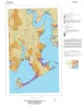
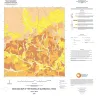
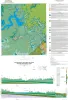
Geologic map of the Olivia and part of the Keller Bay quadrangles, Texas Gulf of Mexico coast | 2020 | Paine, J.G., Costard, L. | Bureau of Economic Geology | |
|
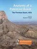
Anatomy of a Paleozoic Basin: The Permian Basin, USA (vol. 2) | 2020 | This is Volume 2 of a two-volume set. The set is the first comprehensive analysis of the Permian Basin in more than 60 years. Collectively, these chapters provide a spectrum of data and interpretations that characterize one of the largest hydrocarbon-producing super basins in the world. |
Ruppel, S.C. | Bureau of Economic Geology |
|
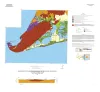
Geologic map of the Lake Stephenson and part of the Smith Point quadrangles, Texas Gulf of Mexico coast | 2020 | Caudle, T.L., Paine, J.G. | Bureau of Economic Geology | |
|
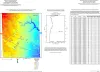
Geologic map of the Port Lavaca West quadrangle, Texas Gulf of Mexico coast | 2019 | Paine, J.G., Costard, L. | Bureau of Economic Geology | |
|
Net Social Cost of Electricity: Policy Smog and Waning Competitive Markets, Lack of Consumer Participation, Importance of the Grid, and Scalability Challenge | 2019 | The purpose of this report is to demonstrate that the time is ripe for a rational, multifaceted, fresh look at the technology, economics, and negative as well as positive externalities of electricity service in the United States. |
Gulen, Gurcan | Bureau of Economic Geology |
|
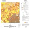
Geologic map of the Rossville quadrangle, Texas | 2019 | Elliott, Brent A. | Bureau of Economic Geology | |
|
Geologic map of the Leming quadrangle, Texas | 2019 | Elliott, Brent A. | Bureau of Economic Geology | |
|
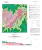
Geologic map of the Pedernales Falls quadrangle, Blanco County, Texas | 2019 | Woodruff, C.M., Jr., Costard, L., Barnes, V.E. | Bureau of Economic Geology | |
|
Anatomy of a Paleozoic Basin: The Permian Basin, USA (vol. 1) | 2019 | This is Volume 1 of a two-volume set. The set is the first comprehensive analysis of the Permian Basin in more than 60 years. Collectively, these chapters provide a spectrum of data and interpretations that characterize one of the largest hydrocarbon-producing super basins in the world. |
Ruppel, S.C. | Bureau of Economic Geology |
|
Geologic map of the lower Lake Travis and Lake Austin vicinity, Texas | 2019 | Woodruff, C.M., Jr., Collins, E.W. | Bureau of Economic Geology |