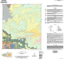
During the Cretaceous Late Albian Stage, extensive carbonate deposition occurred across Texas. Many of these carbonates have been well studied, leading to numerous publications. This investigation focuses on the less-studied Upper Albian Fort Lancaster Formation in the Trans-Pecos region. Carbonates in this area were deposited in the shelf interior northwest of the high-energy northern margin of the Maverick Intrashelf Basin, situated on the Comanche Shelf. Later karsting and faulting significantly altered the rocks.
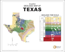
This full-color poster shows a simplified geologic map of Texas created for classroom learning and general interest. The map highlights the major rock types and geologic regions of the state, helping viewers see how Texas was formed over hundreds of millions of years. Alongside the map is a geologic time scale arranged by Age, Era, Period, and Characteristic life, which connects the rocks on the map to Earth’s history and the plants and animals that lived at the time.
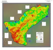
A series of two 1:900,000 scale maps showing the Geothermal resources of Onshore Gulf Coast Texas.