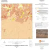
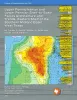
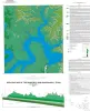
Publication Search

Bureau of Economic Geology Publications

Title Publication Year Sort ascending Abstract Author Publisher
Geologic Map of the White Hills Quadrangle, Texas Geologic Map of the White Hills Quadrangle, Texas 2016 Elliott, Brent A. Bureau of Economic Geology
Architectural Variability and Depositional Trends in the Wilcox Group in Texas Architectural Variability and Depositional Trends in the Wilcox Group in Texas 2016 Olariu, M.I., Ambrose, W.A., Clift, S.J., Clayton, Austin, Li, Shunli, Olariu, Cornel, Steel, Ronald., Zeng, Hongliu Bureau of Economic Geology
Geologic map of the upper Lake Travis area, Texas Geologic map of the upper Lake Travis area, Texas 2016 Woodruff, C.M., Jr., Collins, E.W. Bureau of Economic Geology
Geologic map of the Woodsboro quadrangle: Aransas and Mission Rivers, and Copano Bay area, Texas Gulf of Mexico Coast Geologic map of the Woodsboro quadrangle: Aransas and Mission Rivers, and Copano Bay area, Texas Gulf of Mexico Coast 2015 Paine, J.G., Collins, E.W., Costard, L. Bureau of Economic Geology
Geologic map of the Muenster West quadrangle, Texas Geologic map of the Muenster West quadrangle, Texas 2015 Collins, E.W. Bureau of Economic Geology
Geologic map of the Pace Bend quadrangle, Texas Geologic map of the Pace Bend quadrangle, Texas 2015 Woodruff, C.M., Jr., Collins, E.W. Bureau of Economic Geology
Anatomy of a Giant Carbonate Reservoir: Fullerton Clear Fork (Lower Permian) Field, Permian Basin, Texas Anatomy of a Giant Carbonate Reservoir: Fullerton Clear Fork (Lower Permian) Field, Permian Basin, Texas 2015 Ruppel, S.C. Bureau of Economic Geology
Geologic map of the Silver King Canyon quadrangle, Texas Geologic map of the Silver King Canyon quadrangle, Texas 2015 Elliott, Brent A. Bureau of Economic Geology
Geologic map of the Spice Rock quadrangle, Texas Geologic map of the Spice Rock quadrangle, Texas 2015 Elliott, Brent A. Bureau of Economic Geology
 Pennsylvanian Tidal Depositional Systems in the Anadarko Basin, Northeast Texas Panhandle and Northwest Oklahoma Pennsylvanian Tidal Depositional Systems in the Anadarko Basin, Northeast Texas Panhandle and Northwest Oklahoma 2015

A thick (>6,000-ft [>1,830-m]) succession of Desmoinesian to Virgilian (Pennsylvanian) strata in the northwest part of the Anadarko Basin contains a variety of tide-modified deposits.

Ambrose, W.A., Tussey, L.B. Bureau of Economic Geology