Bureau of Economic Geology Publications
| Title | Publication Year Sort ascending | Abstract | Author | Publisher | |
|---|---|---|---|---|---|
|
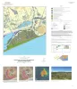
Geologic map of the High Island quadrangle, Texas Gulf of Mexico Coast | 2022 | Caudle, T.L., Paine, J.G., Andrews, J.R. | Bureau of Economic Geology | |
|
Geologic map of the Palacios NE quadrangle, Texas Gulf of Mexico Coast | 2022 | Paine, J.G., Costard, L. | Bureau of Economic Geology | |
|
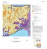
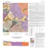
Geologic Map of the Bee Cave Quadrangle, Travis County, Texas | 2022 | Geology illustrated on this map and accompanying geologic map database was revised using field, aerial-photograph, and LiDAR interpretations following a review of previous work on the area’s geology. |
Hunt, B.B., Andrews, J.R. | Bureau of Economic Geology |
|
Geologic map of the Palacios SE quadrangle, Texas Gulf of Mexico Coast | 2022 | Paine, J.G., Costard, L., Caudle, T.L. | Bureau of Economic Geology | |
|
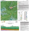
Geologic map of the Mason Quadrangle, Mason County, Texas | 2022 | Hunt, B.B., Johnson, B., Helper, M.A., Droxler, A. | Bureau of Economic Geology | |
|
Oil and gas in fractured crystalline igneous and metamorphic rocks: global overview and examples from Texas | 2021 | Oil and gas resources in crystalline igneous and metamorphic reservoirs are well documented globally and in Texas. |
Shuster, M.W., Zahm, C.K., Hennings, P.H. | Bureau of Economic Geology |
|
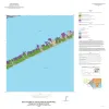
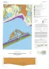
Geologic map of the Frozen Point and Caplen quadrangles, Texas Gulf of Mexico coast | 2021 | Caudle, T.L., Paine, J.G. | Bureau of Economic Geology | |
|
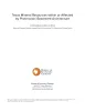
Texas mineral resources within or affected by Proterozoic basement architecture | 2021 | Proterozoic exposures in the Llano Uplift of Central Texas and in the Van Horn area and other smaller areas of western Texas represent less than one percent of the area underlain by Precambrian basement. |
Kyle, J.R., Elliott, Brent A. | Bureau of Economic Geology |
|
Geologic map of the Palacios and part of the Palacios Point quadrangles, Texas Gulf of Mexico coast | 2021 | Paine, J.G., Costard, L. | Bureau of Economic Geology | |
|
Hydrogeology of the Texas basement | 2021 | The tectonically quiescent Proterozoic (Texas craton) and Paleozoic (Gulf Coast) basement of Texas shows large contrasts in hydrogeological behavior, from being a fresh-water aquifer, where it crops out, to forming the base of several large sedimentary basins at depths >7 km (>23,000 ft). |
Nicot, J.P. | Bureau of Economic Geology |