Publications by Morris, J.N.
| Title | Publication Year Sort ascending | Abstract | Author | Series | Publisher | |
|---|---|---|---|---|---|---|
|
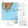
Geologic map of the Port Ingleside quadrangle, Texas Gulf coast | 2025 | Paine, J.G., Caudle, T.L., Morris, J.N., Grunau, B.A. | Open-File Map | Bureau of Economic Geology | |
|
Geologic map of the Mesquite Bay area, Texas Gulf Coast | 2025 | Paine, J.G., Caudle, T.L., Grunau, B.A., Morris, J.N. | Open-File Map | Bureau of Economic Geology | |
|
Geologic map of the Taft area, Texas Gulf Coast | 2025 | Paine, J.G., Morris, J.N., Grunau, B.A. | Open-File Map | Bureau of Economic Geology | |
|
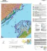
Geologic map of the Copano Bay area, Texas Gulf Coast | 2025 | Paine, J.G., Collins, E.W., Costard, L., Grunau, B.A., Morris, J.N., Caudle, T.L. | Open-File Map | Bureau of Economic Geology | |
|
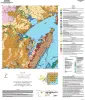
Geologic map of the Austin East quadrangle, Travis County, Texas | 2025 | Morris, J.N., Woodruff, C.M., Jr., Grunau, B.A. | Open-File Map | Bureau of Economic Geology | |
|
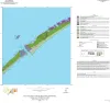
Geologic map of the Decros Point quadrangle, Texas Gulf Of Mexico Coast | 2024 | Aerial imagery used in this study included 0.6- and 1.0-m pixel, natural color, National Agriculture Imagery Program digital imagery photographed in 2020 and 2022. |
Morris, J.N., Paine, J.G. | Open-File Map | Bureau of Economic Geology |
|
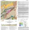
Geologic map of the Loyal Valley quadrangle, Mason County, Texas | 2024 | Hunt, B.B., Helper, M.A., Morris, J.N., Mutis-Duplat, Emilio, Gray, M.W. | Open-File Map | Bureau of Economic Geology | |

|
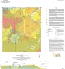
Airborne And Ground Surveys of the April 2023 Daisetta Sinkhole, Liberty County, Texas | 2023 | On Sunday, April 2, 2023, a sinkhole formed on the northwestern flank of the Hull salt dome in the city of Daisetta, Texas (fig 1). |
Paine, J.G., Andrews, J.R., Morris, J.N., Saylam, K., Kyle, J.R. | Open-File Report | Bureau of Economic Geology |
|
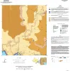
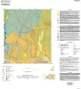
Geologic map of the Montopolis quadrangle, Travis County, Texas | 2023 | This map presents a graphic means for engineers, planners, and property owners to recognize and cope with the changes in substrate properties across this fault zone. Fault displacement has created a profound and abrupt change in land-use capabilities in this area. |
Woodruff, C.M., Jr., Morris, J.N. | Open-File Map | Bureau of Economic Geology |