Publication Details
Publication Year
2025
DOI
10.23867/OFM0302
Map Scale
1:24000
Publication Code
OFM0302
Series
Open-File Map
Publisher
Geolocation:
Get the Publication
Available to Purchase:
$15.00
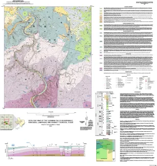
Citation:
Hunt, B. B., and Helper, M. A., 2025, Geologic map of the Gorman Falls quadrangle, San Saba, Lampasas and Burnet Counties, Texas: University of Texas at Austin, Bureau of Economic Geology, Open-File Map 302, scale 1:24,000.