|
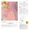
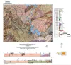
Bedrock Geologic Map of the Fly Gap Quadrangle, Mason County, Texas |
2025 |
|
Hunt, B.B., Helper, M.A., Droddy, Jr., M.J. |
Open-File Map |
Bureau of Economic Geology |
|
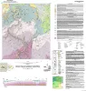
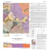
Geologic Map of the Gorman Falls Quadrangle, San Saba, Lampasas and Burnet Counties, Texas |
2025 |
|
Hunt, B.B., Helper, M.A. |
Open-File Map |
Bureau of Economic Geology |
|
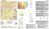
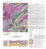
Geologic Map of the Toyahvale Quadrangle, Jeff Davis and Reeves Counties, Texas |
2025 |
|
Hunt, B.B., Helper, M.A., Horne, E.A., Hennings, P.H., Rhoden, E. |
Open-File Map |
Bureau of Economic Geology |
|
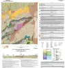
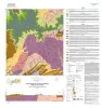
Geologic map of the Loyal Valley quadrangle, Mason County, Texas |
2024 |
|
Hunt, B.B., Helper, M.A., Morris, J.N., Mutis-Duplat, Emilio, Gray, M.W. |
Open-File Map |
Bureau of Economic Geology |
|
Geologic map of a Portion of the Southeastern Llano Uplift, Burnet, Llano, and Blanco Counties Texas |
2023 |
|
Helper, M.A., Hunt, B.B., Barnes, V.E. |
Open-File Map |
Bureau of Economic Geology |
|
Geologic map of the Mason Quadrangle, Mason County, Texas |
2022 |
|
Hunt, B.B., Johnson, B., Helper, M.A., Droxler, A. |
Open-File Map |
Bureau of Economic Geology |
|
Geologic map of the Turtle Creek Quadrangle, Mason County, Texas |
2022 |
|
Hunt, B.B., Johnson, B., Helper, M.A., Droxler, A. |
Open-File Map |
Bureau of Economic Geology |
|
Geologic map of the Grit quadrangle, Mason County, Texas |
2021 |
|
Hunt, B.B., Johnson, B., Helper, M.A. |
Open-File Map |
Bureau of Economic Geology |
|
Geology and Historical Mining, Llano Uplift Region, Central Texas |
2000 |
|
Caran, S.C., Helper, M.A., Kyle, J.R. |
Austin Geological Society |
Austin Geological Society |