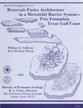
Sandstone reservoirs deposited in microtidal barrier systems contain large oil and gas reserves in several Gulf Coast Basin plays. Three representative Frio Sandstone reservoirs in West Ranch field show that barrier-island sand bodies are complex mosaics of barrier-core, inlet-fill, flood-tidal-delta, washover-fan, barrier-flat, and shoreface facies. The proportions of these facies differ within progradational, aggradational, and transgressive barrier sand bodies.
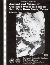
Bedded salt of the Permian San Andres Formation, Palo Duro Basin, Texas, is under consideration for the isolation of high-level nuclear waste. To represent the variety of salt types present, 150 large (250 to 500 g), intact samples of bedded halite from the San Andres Formation and other saltbearing units were selected and then analyzed by a standardized procedure. The halite fraction of the sample was dissolved in anhydrous methanol by continuous reflux Soxhlet extraction, and the water content was measured by Karl Fischer titration.
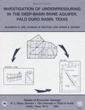
Although plots of pressure versus depth are useful for understanding the hydrodynamics of ground-water systems, they can be difficult to interpret. Data plotted from a confined aquifer may reflect underpressuring because the aquifer is isolated from hydrostatically pressured aquifers (depth intercept is greater than zero) or because there is potential for downward flow within the aquifer (pressure-depth gradient is less than hydrostatic).
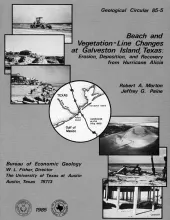
On August 18, 1983, Hurricane Alicia crossed the upper Texas Gulf Coast and caused extensive property damage, especially along West Beach of Galveston Island. Aerial photographs taken before and after Alicia and field measurements made during the first 2 yr after the storm provide a basis for determining nearshore changes associated with a major hurricane and for predicting potential beach recovery. Alicia caused substantial landward retreat of both the shoreline and the vegetation line. Retreat of the vegetation line ranged from 20 to 145 ft and averaged about 80 ft.
Large areas of offshore Texas remain unexplored even though sedimentary facies and structural traps favor the generation and accumulation of hydrocarbons. Rapid deposition of sand-rich deltaic and barrier-strandplain facies that prograded over thick prodelta, shelf, and slope muds initiated contemporaneous faulting, resulting in displacements of as much as 10,000 ft ( 3 km) .The steep fault surfaces extend to great depths at delta depocenters along former shelf margins.