Publications by Brown, T.E.
| Title | Publication Year Sort ascending | Abstract | Author | Series | Publisher | |
|---|---|---|---|---|---|---|
|
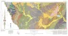
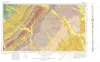
Geologic Atlas of Texas, Crystal City-Eagle Pass sheet | 1976 | Oversize color geologic map that depicts surface geology of Dimmit, LaSalle, and McMullen Counties and parts of Maverick, Zavala, Frio, Atascosa, Karnes, Wilson, Live Oak, Jim Wells, Duval, and Webb Counties, Texas. The 6-page booklet indicates geologic formations, abbreviations, and ages. |
Barnes, V.E., Humble Oil and Refining Co., Shell Oil Co., Amerada Petroleum Corp., Mobil Oil Co., Owens, Frith, Howeth, Ike, Brown, T.E. | Geologic Atlas of Texas | Bureau of Economic Geology |
|
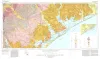
Geologic Atlas of Texas, Beeville-Bay City sheet (revised 1987) | 1975 | Geologic map that depicts the surface geology of Goliad, Refugio, and Calhoun Counties and parts of Karnes, De Witt, Victoria, Jackson, Matagorda, Aransas, San Patricio, Bee, and Live Oak Counties. The 4-page booklet indicates geologic formations, abbreviations, and ages. |
Barnes, V.E., Brown, T.E., Brewton, J.L., Aronow, Saul, Eargle, D.H., Morton, R.G., Maxson, M.J., Wyeth, J.C. | Geologic Atlas of Texas | Bureau of Economic Geology |
|
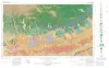
Geologic Atlas of Texas, Austin sheet | 1974 | Geologic map that depicts the surface geology of Burleson, Lee, Washington, and Brazos Counties and parts of Burnet, Bell, Milam, Robertson, Madison, Grimes, Waller, Austin, Fayette, Bastrop, Caldwell, Hays, Travis, and Williamson Counties. |
Barnes, V.E., Shell Oil Co., Humble Oil and Refining Co., Mobil Oil Co., Proctor, C.V., Jr., Brown, T.E., McGowen, J.H., Waechter, N.B. | Geologic Atlas of Texas | Bureau of Economic Geology |
|
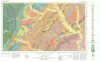
Geologic Atlas of Texas, San Antonio sheet (revised 1982) | 1974 | Geologic map that depicts the surface geology of Comal, Bandera, Bexar, and Medina Counties and parts of Real, Kerr, Kendall, Hays, Guadalupe, Wilson, Atascosa, Frio, Zavala, and Uvalde Counties, Texas. The 9-page booklet indicates geologic formations, abbreviations, and ages. |
Barnes, V.E., Shell Oil Co., Amerada Petroleum Corp., Brown, T.E., Waechter, N.B., Dillon, R.L. | Geologic Atlas of Texas | Bureau of Economic Geology |
|
Geologic Atlas of Texas, Seguin sheet | 1974 | Geologic map that depicts the surface geology of Colorado, Lavaca, and Gonzales Counties, and parts of Hays, Caldwell, Bastrop, Fayette, Austin, Waller, Fort Bend, Wharton, Matagorda, Jackson, Victoria, De Witt, Karnes, Wilson, and Guadalupe Counties, Texas. |
Barnes, V.E., Humble Oil and Refining Co., Shell Oil Co., Mobil Oil Co., Proctor, C.V., Jr., Brown, T.E., Waechter, N.B., Aronow, Saul | Geologic Atlas of Texas | Bureau of Economic Geology |
|
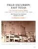
Field excursion East Texas -- clay, glauconite, ironstone deposits | 1969 | Brown, T.E., Newland, L.E., Campbell, D.H., Ehlmann, A.J. | Guidebook | Bureau of Economic Geology | |
|
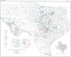
Index to Areal Geologic Maps in Texas | 1963 | In planning for a modern geologic map of the State (scale 1:250,000), a bibliography of published and unpublished geologic maps of areas in Texas was compiled under the direction of Virgil E. Barnes, Director of the Geologic Atlas Project of the Bureau of Economic Geology. |
Brown, T.E. | Miscellaneous Map | |
|
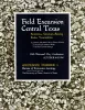
Field excursion central Texas -- bentonites, uranium-bearing rocks, vermiculites | 1961 | The departure point of the Villa Capri Motor Hotel may be gone, but the geologic information within Guidebook Number 3 remains relevant to this day: "The four stops of this field trip are in the Upper Eocene (Jackson) and Oligocene volcanic ash and bentonite beds, which crop out about |
Folk, R.L., Hayes, M.O., Brown, T.E., Eargle, D.H., Weeks, A.D., Barnes, V.E., Clabaugh, S.E. | Guidebook | Bureau of Economic Geology |