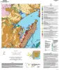
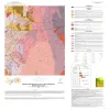
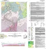
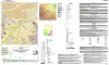
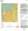
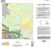
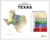
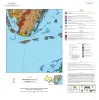
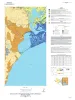
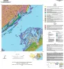
Publication Search

Publications tagged with Geologic Maps

Title Publication Year Sort ascending Abstract Author Series Publisher
Geologic map of the Norton Mesa quadrangle, Texas Geologic map of the Norton Mesa quadrangle, Texas 2024 Elliott, Brent A. Open-File Map Bureau of Economic Geology
Decros Point Quadrangle Thumbnail Geologic map of the Decros Point quadrangle, Texas Gulf Of Mexico Coast 2024

Aerial imagery used in this study included 0.6- and 1.0-m pixel, natural color, National Agriculture Imagery Program digital imagery photographed in 2020 and 2022.

Morris, J.N., Paine, J.G. Open-File Map Bureau of Economic Geology
Geologic map of the Panther Creek quadrangle, Mason County, Texas Geologic map of the Panther Creek quadrangle, Mason County, Texas 2023 Hunt, B.B. Open-File Map Bureau of Economic Geology
Geologic map of the Monument Mountain SE quadrangle, Mason County, Texas Geologic map of the Monument Mountain SE quadrangle, Mason County, Texas 2023 Hunt, B.B. Open-File Map Bureau of Economic Geology
Geologic map of the Dolan Springs quadrangle, Val Verde County, Texas Geologic map of the Dolan Springs quadrangle, Val Verde County, Texas 2023 Hunt, B.B., Andrews, J.R., Paine, J.G. Open-File Map Bureau of Economic Geology
Geologic map of a Portion of the Southeastern Llano Uplift, Burnet, Llano, and Blanco Counties Texas Geologic map of a Portion of the Southeastern Llano Uplift, Burnet, Llano, and Blanco Counties Texas 2023 Helper, M., Hunt, B.B., Barnes, V.E. Open-File Map Bureau of Economic Geology
Thumbnail of OFM0273 Geologic map of the Montopolis quadrangle, Travis County, Texas 2023

This map presents a graphic means for engineers, planners, and property owners to recognize and cope with the changes in substrate properties across this fault zone. Fault displacement has created a profound and abrupt change in land-use capabilities in this area.

Woodruff, C.M., Jr., Morris, J.N. Open-File Map Bureau of Economic Geology
Geologic map of the Turtle Creek Quadrangle, Mason County, Texas Geologic map of the Turtle Creek Quadrangle, Mason County, Texas 2022 Hunt, B.B., Johnson, B., Helper, M., Droxler, A. Open-File Map Bureau of Economic Geology
Bee Cave Quadrangle Map Thumbnail Geologic Map of the Bee Cave Quadrangle, Travis County, Texas 2022

Geology illustrated on this map and accompanying geologic map database was revised using field, aerial-photograph, and LiDAR interpretations following a review of previous work on the area’s geology.

Hunt, B.B., Andrews, J.R. Open-File Map Bureau of Economic Geology
Geologic Map of the Creedmoor Quadrangle, Texas Geologic Map of the Creedmoor Quadrangle, Texas 2022 Woodruff, C.M., Jr., Costard, L. Open-File Map Bureau of Economic Geology