Publication Year
1985
Publisher
Series
Gulf Coast Section SEPM
Publication Year
1985
Publisher
Series
Texas Memorial Museum
Publication Year
1985
Series
Annual Reports
Abstract
Annual report for the Bureau of Economic Geology 1985
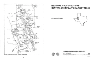
Publication Year
1985
Series
Cross Sections
Abstract
In 1982, the Bureau of Economic Geology initiated a project to characterize the major oil fields of Texas. The project led to the compilation of an atlas summarizing the general geologic setting and production statistics of all fields that have produced more than 10 million barrels of oil (Galloway and others, 1983). During this compilation, the need arose for regional stratigraphic control for the various large fields on the Central Basin Platform, and these cross sections were constructed to fill this need.
Publication Year
1985
Publisher
Series
River Basins Regional Studies