One nonconventional target for increased oil recovery in Texas is oil that remains in abandoned reservoirs, defined as reservoirs that produced no oil or gas in 1977 and 1982. This target includes oil in reservoirs that were never subjected to modern secondary or tertiary recovery methods as well as oil that was not tapped by conventional field development because of reservoir heterogeneity.
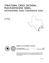
These cross sections numerically correspond to previously published onshore cross sections (CS0002--Dodge and Posey, 1981) and extend those sections across the continental shelf into the Miocene, a recent target of renewed petroleum exploration. Lithostratigraphic markers, corresponding to commonly used paleontological markers, have been used to correlate and subdivide the Miocene Series, which constitutes the largest volume of sedimentary fill in the offshore western Gulf Coast Basin.
This folded transparent map is at the same scale as its corresponding Geologic Atlas of Texas (GAT) sheet and can be superimposed on it to compare gravity information with surface geology.