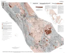
Publication Year
1985
Publisher
Series
Miscellaneous Map
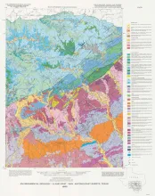
Publication Year
1985
Publisher
Series
River Basins Regional Studies
Publication Year
1985
Publisher
Series
Geological Folios
Publication Year
1985
Publisher
Series
Mineral Resource Circular
Publication Year
1985
Publisher
Series
Report of Investigations
Abstract
Silver deposits occur in Precambrian, Permian, and Cretaceous red-bed sequences near Van Horn, Texas. These deposits are geochemically similar and contain economically important quantities of silver, copper, and lead, as well as anomalously high amounts of arsenic, zinc, cadmium, and molybdenum. Gold is not enriched. Primary minerals include chalcopyrite, tennantite-tetrahedrite, bornite, galena, sphalerite, acanthite, pyrite, marcasite, barite, and calcite. The deposits are dominantly steeply dipping veins. Strata-bound occurrences are near veins or closely spaced fractures.