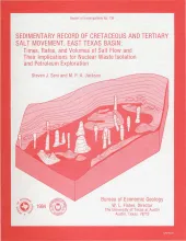
Post-Aptian strata (younger than 112 ma) in the East Texas Basin were strongly influenced by halokinesis and recorded the evolution associated sate structures. Comparisons with model diapirs and dome-induced changes in patterns of sandstone distribution, depositional facies, and reef growth indicate that thickness variations in strata surrounding domes were caused by syndepositional processes rather than by tectonic distortion. Salt domes in the East Texas Basin exhibit three stages of growth: pillow, diaper, and postdiapir. Each stage affected surrounding strata differently.
Thirty-one low-permeability gas-bearing sandstones in 15 sedimentary basins were surveyed to delineate the major depositional systems and associated facies of each stratigraphic unit. The depositional system of each unit provides a basis of comparison between formations of different ages in different structural and sedimentary settings. Information as compiled on general attributes, economic factors, geologic parameters of the basin or trend, geologic and engineering parameters of the stratigraphic unit, and operating conditions at each formation or member.
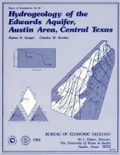
The Edwards Formation, on the downthrown side of Mt. Bonnell fault in the Austin, Texas, area (Hays and Travis Counties), is part of the northeastern extension of the Edwards Underground Reservoir, the primary source of water in numerous counties along the Balcones Fault Zone. Recharge to the aquifer is supplied mainly by creeks that cross the Balcones Fault Zone southwest of Austin. Barton Springs is the major point of discharge. Changes in water levels of wells in the area correlate positively with changes in discharge at Barton Springs, suggesting good interconnection.
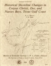
Changes in the position and stability of shorelines around Corpus Christi, Oso, and Nueces Bays, Texas Gulf Coast, were documented using historical-monitoring techniques.
Deep-water sandstones of the Oligocene-age Hackberry unit of the Frio Formation contain significant quantities of oil and gas and remain potentially one of the most productive exploration targets in southeast Texas. The Hackberry is a wedge of sandstone and shale containing bathyal fauna that separates upper Frio barrier-bar - strandplain sandstones from lower Frio neritic shale and sand. Major Hackberry sandstones lie atop a channeled unconformity that forms the base of the unit.