Sabine Pass Publications
| Title | Publication Year Sort ascending | Abstract | Author | Series | Publisher | |
|---|---|---|---|---|---|---|
| |
Gulf of Mexico Shoreline Change, High Island to Sabine Pass, Texas | 2021 | Caudle, T.L., Paine, J.G., Andrews, J.R., Suarez, J.R. | Posters | ||
|
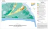
Geoenvironmental map of Sabine Pass and Texas Point quadrangles, Texas, Gulf of Mexico Coast | 2009 | Tremblay, T.A., White, W.A., Caudle, T.L. | Open-File Map | Bureau of Economic Geology | |
|
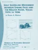
Gulf shoreline movement between Sabine Pass and the Brazos River, Texas: 1974 to 1996 | 1997 | Changes in shoreline position along the southeastern Texas Gulf coast between 1974 and 1996 were documented by conducting a kinematic real-time differential global positioning system (DGPS) field survey in 1996 and comparing that shoreline with other shorelines archived in a geographic informatio |
Morton, R.A. | Geological Circular | Bureau of Economic Geology |
|
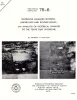
Shoreline changes between Sabine Pass and Bolivar Roads -- an analysis of historical changes of the Texas Gulf shoreline | 1975 | Historical monitoring between Sabine Pass and Bolivar Roads records the nature and magnitude of changes in position of the shoreline and vegetation line and provides insight into the factors affecting those changes. |
Morton, R.A. | Geological Circular | Bureau of Economic Geology |