Publications by Aronow, Saul
| Title | Publication Year Sort ascending | Abstract | Author | Series | Publisher | |
|---|---|---|---|---|---|---|
|
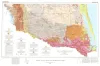
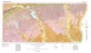
Geologic Atlas of Texas, McAllen-Brownsville sheet | 1976 | Geologic map that depicts surface geology of Starr, Hidalgo, Willacy, and Cameron Counties and parts of Zapata, Jim Hogg, Brooks, and Kenedy Counties. |
Barnes, V.E., Humble Oil and Refining Co., Shell Oil Co., Mobil Oil Co., Owens, Frith, Brewton, J.L., Aronow, Saul, Martin, R.G. | Geologic Atlas of Texas | Bureau of Economic Geology |
|
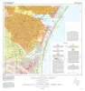
Geologic Atlas of Texas, Corpus Christi sheet | 1975 | Geologic map that depicts the surface geology of Nueces County and parts of Jim Wells, San Patricio, Aransas, Kleberg, and Kenedy Counties. |
Barnes, V.E., Aronow, Saul, Humble Oil and Refining Co., Martin, R.G., Maxson, M.J., Wyeth, J.C., Knupke, J.A., Buck, C.E. | Geologic Atlas of Texas | Bureau of Economic Geology |
|
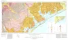
Geologic Atlas of Texas, Beeville-Bay City sheet (revised 1987) | 1975 | Geologic map that depicts the surface geology of Goliad, Refugio, and Calhoun Counties and parts of Karnes, De Witt, Victoria, Jackson, Matagorda, Aransas, San Patricio, Bee, and Live Oak Counties. The 4-page booklet indicates geologic formations, abbreviations, and ages. |
Barnes, V.E., Brown, T.E., Brewton, J.L., Aronow, Saul, Eargle, D.H., Morton, R.G., Maxson, M.J., Wyeth, J.C. | Geologic Atlas of Texas | Bureau of Economic Geology |
|
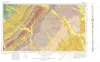
Geologic Atlas of Texas, Seguin sheet | 1974 | Geologic map that depicts the surface geology of Colorado, Lavaca, and Gonzales Counties, and parts of Hays, Caldwell, Bastrop, Fayette, Austin, Waller, Fort Bend, Wharton, Matagorda, Jackson, Victoria, De Witt, Karnes, Wilson, and Guadalupe Counties, Texas. |
Barnes, V.E., Humble Oil and Refining Co., Shell Oil Co., Mobil Oil Co., Proctor, C.V., Jr., Brown, T.E., Waechter, N.B., Aronow, Saul | Geologic Atlas of Texas | Bureau of Economic Geology |
|
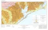
Geologic Atlas of Texas, Houston sheet (revised 1982) | 1968 | Geologic map that depicts the surface geology of Galveston and Chambers Counties and parts of Waller, Harris, Liberty, Jefferson, Orange, Brazoria, Matagorda, Wharton, and Fort Bend Counties. |
Barnes, V.E., Aronow, Saul, LeBlanc, R.J., Evans, F.G., Hinds, G.W., Holland, W.C., Van Siclen, D.C., Macon, J.W. | Geologic Atlas of Texas | Bureau of Economic Geology |
|
Geologic Atlas of Texas, Beaumont sheet (revised 1992) | 1968 | Geologic map that depicts the surface geology of Montgomery, San Jacinto, and Hardin Counties and parts of Madison, Trinity, Polk, Tyler, Jasper, Newton, Orange, Jefferson, Liberty, Harris, Waller, Grimes, Walker, and Robertson Counties. |
Barnes, V.E., Humble Oil and Refining Co., Shell Oil Co., Aronow, Saul, Shelby, C.A., Eargle, D.H., LeBlanc, R.J., Evans, F.G. | Geologic Atlas of Texas | Bureau of Economic Geology |