Bureau of Economic Geology Publications
| Title | Publication Year Sort ascending | Abstract | Author | Publisher | |
|---|---|---|---|---|---|
|
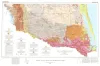
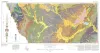
Geologic Atlas of Texas, McAllen-Brownsville sheet | 1976 | Geologic map that depicts surface geology of Starr, Hidalgo, Willacy, and Cameron Counties and parts of Zapata, Jim Hogg, Brooks, and Kenedy Counties. |
Barnes, V.E., Humble Oil and Refining Co., Shell Oil Co., Mobil Oil Co., Owens, Frith, Brewton, J.L., Aronow, Saul, Martin, R.G. | Bureau of Economic Geology |
|
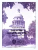
Guide to points of geologic interest in Austin | 1976 | Trippet, A.R., Garner, L.E. | Bureau of Economic Geology | |
|
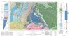
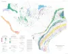
Environmental geologic Atlas of the Texas coastal zone -- Port Lavaca area | 1976 | The Texas Coastal Zone is marked by diversity in geography, resources, climate, and industry. |
McGowen, J.H., Proctor, C.V., Jr., Brown, L.F., Jr., Evans, T.J., Fisher, W.L., Groat, C.G. | Bureau of Economic Geology |
|
Geologic Atlas of Texas, Brownwood sheet | 1976 | Geologic map that depicts the surface geology of Mills County and parts of Runnels, Coleman, Brown, Comanche, Erath, Hamilton, Coryell, Lampasas, San Saba, McCulloch, Concho, and Menard Counties. The 21-page booklet indicates geologic formations, abbreviations, and ages. |
Kier, R.S., Harwood, P., Brown, L.F., Jr., Goodson, J.L., Barnes, V.E., Shell Oil Co., Humble Oil and Refining Co., Southern Minerals Corp. | Bureau of Economic Geology |

|
Geologic Atlas of Texas, Pecos sheet | 1976 | Geologic map that depicts the surface geology of Loving, Crane, and Ward Counties and parts of Ector, Midland, Upton, Pecos, Reeves, Crockett, and Winkler Counties, Texas. The 5-page booklet indicates geologic formations, abbreviations, and ages. |
Barnes, V.E., Eifler, G.K., Shell Oil Co., Cities Service Petroleum Co., Brown, J.B. | Bureau of Economic Geology |
|
Geologic Atlas of Texas, Crystal City-Eagle Pass sheet | 1976 | Oversize color geologic map that depicts surface geology of Dimmit, LaSalle, and McMullen Counties and parts of Maverick, Zavala, Frio, Atascosa, Karnes, Wilson, Live Oak, Jim Wells, Duval, and Webb Counties, Texas. The 6-page booklet indicates geologic formations, abbreviations, and ages. |
Barnes, V.E., Humble Oil and Refining Co., Shell Oil Co., Amerada Petroleum Corp., Mobil Oil Co., Owens, Frith, Howeth, Ike, Brown, T.E. | Bureau of Economic Geology |
|
Energy resources of Texas | 1976 | This large-scale map of Texas displays the full range and scope of energy resources in the State. Oil and gas fields are shown according to the age of the producing reservoir. |
St. Clair, A.E., Evans, T.J., Garner, L.E. | Bureau of Economic Geology |
|
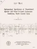
Hydrogeologic significance of depositional systems and facies in Lower Cretaceous sandstones, north-central Texas | 1976 | The Lower Cretaceous Hosston and Hensel Sandstones are important sources of ground water in North-Central Texas. |
Hall, W.D. | Bureau of Economic Geology |
|
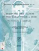
Lineations and faults in the Texas coastal zone | 1976 | Over 7,000 miles of lineations have been observed on aerial photographic mosaics of the Texas Coastal Zone. These lineations, in part, represent the surface traces of faults originating in the Tertiary sediments and propagating through the Quaternary sediments. |
Kreitler, C.W. | Bureau of Economic Geology |
|
Land Resources Inventory of Lignite Strip-Mining Areas, East Texas: An Application of Environmental Geology | 1976 | With the growing concern for finding new sources of energy, there has been renewed interest in an old source, lignite. In the past few years, Texas lignite has been "rediscovered", and a wave of lignite exploration rivals the early oil booms of Texas history. |
Henry, C.D. | Bureau of Economic Geology |