Bureau of Economic Geology Publications
| Title | Publication Year Sort ascending | Abstract | Author | Publisher | |
|---|---|---|---|---|---|

|
Landsat analysis of the Texas coastal zone | 1979 | Mapping based on Landsat imagery was initiated along the Texas coast for four test sites selected for contrasting vegetation, environmental geology, and levels of economic development. |
Finley, R.J. | Bureau of Economic Geology |
|
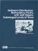
Sediment distribution, bathymetry, faults, and salt diapirs, submerged lands of Texas | 1979 | The State-owned submerged lands of Texas encompass nearly 6,000 square miles (15,540 km²) and extend from Mexico to Louisiana. The area includes the bays, estuaries, and lagoons, as well as the inner continental shelf 10.3 miles (16.6 km) seaward of the Gulf shoreline (fig. 1). |
McGowen, J.H., Morton, R.A. | Bureau of Economic Geology |
|
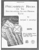
Precambrian rocks of the southeastern Llano region, Texas | 1979 | Precambrian sedimentary rocks and associated mafic and silicic igneous rocks in Central Texas underwent a single episode of regional metamorphism about 1,050 million years (m.y.) ago. |
McGehee, R.V. | Bureau of Economic Geology |
|
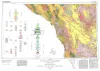
Geologic Atlas of Texas, Marfa sheet | 1979 | Geologic map that depicts surface geology of parts of Hudspeth, Culberson, Jeff Davis, and Presidio Counties, Texas. The 12-page explanatory booklet indicates geologic formations, abbreviations, and ages. |
Barnes, V.E., Twiss, P.C., Continental Oil Co., Cities Service Petroleum Co., Geophoto Services Inc., Norman, D.M., Sherrod, C.H., Pearson, B.T. | Bureau of Economic Geology |
|
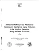
Sandstone distribution and potential for geopressured geothermal energy production in the Vicksburg Formation along the Texas Gulf coast | 1979 | Potential geopressured geothermal reservoirs in the Vicksburg Formation are limited to Hidalgo County along the Lower Texas Gulf Coast. |
Loucks, R.G. | Bureau of Economic Geology |
|
Geologic setting and geochemistry of thermal water and geothermal assessment, Trans-Pecos Texas | 1979 | Hot springs and wells in West Texas and adjacent Mexico are manifestations of active convective geothermal systems concentrated in a zone along the Rio Grande between the Quitman Mountains and Big Bend National Park. |
Henry, C.D. | Bureau of Economic Geology |
|
Depositional framework of the Lower Dockum Group (Triassic), Texas panhandle | 1979 | The Upper Triassic Dockum Group of Texas and New Mexico is composed of 200 to 2,000 feet of complexly interrelated terrigenous clastic facies ranging from mudstone to conglomerate. |
McGowen, J.H., Granata, G.E., Seni, S.J. | Bureau of Economic Geology |
|
Electric Power Generation from Texas Lignite | 1978 | Lignite is a rediscovered energy in Texas because lignite-produced energy is 3 to 7 times cheaper than intrastate natural gas. Production has risen from 18,000 short tons in 1950 to 14 million tons in 1976 and will exceed 50 million tons by 1985. |
Kaiser, W.R. | Bureau of Economic Geology |
|
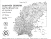
Sand-body geometry and the occurrence of lignite in the Eocene of Texas | 1978 | Lignite occurs in three Eocene stratigraphic units--the Wilcox Group, Yegua Formation, and Jackson Group--and in three ancient depositional systems-fluvial, deltaic, and strandplain/lagoonal. |
Kaiser, W.R., Johnston, J.E., Bach, W.N. | Bureau of Economic Geology |
|
Texas Energy Reserves and Resources | 1978 | Contributing about 25 percent of all the energy ever produced in the United States, Texas has for 50 years led the nation in energy production. |
Fisher, W.L. | Bureau of Economic Geology |