Bureau of Economic Geology Publications
| Title | Publication Year Sort ascending | Abstract | Author | Publisher | |
|---|---|---|---|---|---|
|
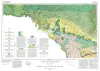
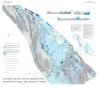
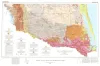
Geologic Atlas of Texas, Del Rio sheet | 1977 | Geologic map that depicts surface geology of Kinney County and parts of Terrell, Val Verde, Edwards, Real, Uvalde, and Maverick Counties, Texas. |
Barnes, V.E., Waechter, N.B., Pinkley, G.R., Martin, R.G., Wyeth, J.C., Knupke, J.A., Sulik, J.F., Ellis, W.G. | Bureau of Economic Geology |
|
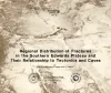
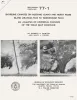
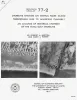
Regional distribution of fractures in the southern Edwards Plateau and their relationship to tectonics and caves | 1977 | In order to better understand the control exerted by fractures on the recharge and production zones of limestone aquifers, the authors delineated surficial fracture zones in the southern Edwards Plateau, Texas. Lineations were marked on nearly 200 mosaics scale of 1:24,000. |
Wermund, E.G., Cepeda, J.C., Luttrell, P.E. | Bureau of Economic Geology |
|
Catahoula Formation of the Texas coastal plain: depositional systems, composition, structural development, ground-water flow history, and uranium distribution | 1977 | The Catahoula Formation of the Texas Gulf Coastal Plain consists of two depositional systems--the Gueydan bedload fluvial system of the Rio Grande embayment and the Chita-Corrigan mixed load fluvial system of the Houston embayment. |
Galloway, W.E., Murphy, T.D., Belcher, R.C., Johnson, B.D., Sutton, Stanley | Bureau of Economic Geology |
|
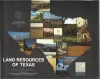
Land resources of Texas | 1977 | Texas is endowed with an enormous variety of natural land resources that vary from the humid forest lands of East Texas to the vast desert lands of Trans-Pecos, from the swamps and marshes of the Texas Coastal Zone to the arid plains of the Panhandle, and from the rich farmland of Central Texas t |
Kier, R.S., Garner, L.E., Brown, L.F., Jr., University of Texas at Austin, Bureau of Economic Geology | Bureau of Economic Geology |
|
Tectonic map of the Rio Grande area, Trans-Pecos Texas and adjacent Mexico | 1977 | Henry, C.D., Bockoven, N.T. | Bureau of Economic Geology | |
|
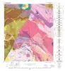
Geology of the Click Quadrangle, Llano and Blanco Counties, Texas | 1977 | Barnes, V.E. | Bureau of Economic Geology | |
|
Shoreline changes on Mustang Island and North Padre Island (Aransas Pass to Yarborough Pass) -- an analysis of historical changes of the Texas Gulf shoreline | 1977 | Historical monitoring along Mustang and north Padre Islands records the nature and magnitude of changes in position of the shoreline and vegetation line and provides insight into the factors affecting those changes. |
Morton, R.A., Pieper, M.J. | Bureau of Economic Geology |
|
Shoreline changes on central Padre Island (Yarborough Pass to Mansfield Channel) -- an analysis of historical changes of the Texas Gulf shoreline | 1977 | Historical monitoring along central Padre Island records the nature and magnitude of changes in position of the shoreline and vegetation line and provides insight into the factors affecting those changes. |
Morton, R.A., Pieper, M.J. | Bureau of Economic Geology |
|
Geologic Atlas of Texas, McAllen-Brownsville sheet | 1976 | Geologic map that depicts surface geology of Starr, Hidalgo, Willacy, and Cameron Counties and parts of Zapata, Jim Hogg, Brooks, and Kenedy Counties. |
Barnes, V.E., Humble Oil and Refining Co., Shell Oil Co., Mobil Oil Co., Owens, Frith, Brewton, J.L., Aronow, Saul, Martin, R.G. | Bureau of Economic Geology |
|
Guide to points of geologic interest in Austin | 1976 | Trippet, A.R., Garner, L.E. | Bureau of Economic Geology |