Publications by Mobil Oil Co.
| Title | Publication Year Sort ascending | Abstract | Author | Series | Publisher | |
|---|---|---|---|---|---|---|
|
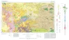
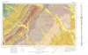
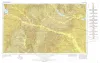
Geologic Atlas of Texas, Fort Stockton sheet (revised 1994) | 1982 | Geologic map that depicts the surface geology of parts of Jeff Davis, Reeves, Pecos, Terrell, Brewster, and Presidio Counties, Texas. The 9-page booklet indicates geologic formations, abbreviations, and ages. |
Barnes, V.E., Humboldt Oil and Refining Co., Mobil Oil Co., Geophoto Services Inc., Cities Service Petroleum Co., Anderson, J.E., Brown, J.B., Gries, J.C. | Geologic Atlas of Texas | Bureau of Economic Geology |
| |
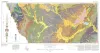
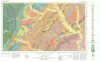
Geologic Atlas of Texas, Emory Peak-Presidio sheet | 1979 | Geologic map that depicts the surface geology of parts of Presidio, Brewster, and Terrell Counties, Texas. The 14-page booklet indicates geologic formations, abbreviations, and ages. |
Barnes, V.E., Geophoto Services Inc., Cities Service Petroleum Co., Mobil Oil Co., Cepeda, N.J., Daugherty, F.W., Brown, J.B., Norman, D.B. | Geologic Atlas of Texas | Bureau of Economic Geology |
|
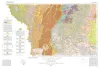
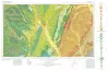
Geologic Atlas of Texas, Crystal City-Eagle Pass sheet | 1976 | Oversize color geologic map that depicts surface geology of Dimmit, LaSalle, and McMullen Counties and parts of Maverick, Zavala, Frio, Atascosa, Karnes, Wilson, Live Oak, Jim Wells, Duval, and Webb Counties, Texas. The 6-page booklet indicates geologic formations, abbreviations, and ages. |
Barnes, V.E., Humble Oil and Refining Co., Shell Oil Co., Amerada Petroleum Corp., Mobil Oil Co., Owens, Frith, Howeth, Ike, Brown, T.E. | Geologic Atlas of Texas | Bureau of Economic Geology |
|
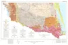
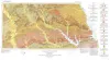
Geologic Atlas of Texas, Laredo sheet | 1976 | Geologic map that depicts the surface geology of parts of Webb, Duval, Jim Wells, Kleberg, Brooks, Jim Hogg, and Zapata Counties |
Barnes, V.E., Mobil Oil Co., Shell Oil Co., Humble Oil and Refining Co., Owens, Frith, Brewton, J.L., Tobin, Edward, Martin, R.G. | Geologic Atlas of Texas | Bureau of Economic Geology |
|
Geologic Atlas of Texas, McAllen-Brownsville sheet | 1976 | Geologic map that depicts surface geology of Starr, Hidalgo, Willacy, and Cameron Counties and parts of Zapata, Jim Hogg, Brooks, and Kenedy Counties. |
Barnes, V.E., Humble Oil and Refining Co., Shell Oil Co., Mobil Oil Co., Owens, Frith, Brewton, J.L., Aronow, Saul, Martin, R.G. | Geologic Atlas of Texas | Bureau of Economic Geology |
|
Geologic Atlas of Texas, Seguin sheet | 1974 | Geologic map that depicts the surface geology of Colorado, Lavaca, and Gonzales Counties, and parts of Hays, Caldwell, Bastrop, Fayette, Austin, Waller, Fort Bend, Wharton, Matagorda, Jackson, Victoria, De Witt, Karnes, Wilson, and Guadalupe Counties, Texas. |
Barnes, V.E., Humble Oil and Refining Co., Shell Oil Co., Mobil Oil Co., Proctor, C.V., Jr., Brown, T.E., Waechter, N.B., Aronow, Saul | Geologic Atlas of Texas | Bureau of Economic Geology |
|
Geologic Atlas of Texas, Austin sheet | 1974 | Geologic map that depicts the surface geology of Burleson, Lee, Washington, and Brazos Counties and parts of Burnet, Bell, Milam, Robertson, Madison, Grimes, Waller, Austin, Fayette, Bastrop, Caldwell, Hays, Travis, and Williamson Counties. |
Barnes, V.E., Shell Oil Co., Humble Oil and Refining Co., Mobil Oil Co., Proctor, C.V., Jr., Brown, T.E., McGowen, J.H., Waechter, N.B. | Geologic Atlas of Texas | Bureau of Economic Geology |
|
Geologic Atlas of Texas, Waco sheet | 1970 | Geologic maps that depicts the surface geology of McLennan, Limestone, and Falls Counties and parts of Bosque, Hill, Navarro, Freestone, Leon, Madison, Robertson, Milam, Bell, Lampasas, Coryell, and Hamilton Counties, Texas. |
Barnes, V.E., Humble Oil and Refining Co., Shell Oil Co., Mobil Oil Co., Proctor, C.V., Jr., McGowen, J.H., Haenggi, W.T., Hayward, O.T. | Geologic Atlas of Texas | Bureau of Economic Geology |
|
Geologic Atlas of Texas, Palestine sheet (revised 1993) | 1967 | Geologic map that depicts the surface geology of Nacogdoches, Shelby, San Augustine, Sabine, and Angelina Counties and parts of Anderson, Cherokee, Rusk, Newton, Jasper, Tyler, Polk, Trinity, Robertson, Madison, Leon, Freestone, and Panola Counties, Texas. |
Barnes, V.E., Humble Oil and Refining Co., Shell Oil Co., Pan American Petroleum Corp., Mobil Oil Co., Wright, A.C., McCallum, H.D., Wendlandt, E.A. | Geologic Atlas of Texas | Bureau of Economic Geology |
|
Geologic Atlas of Texas, Tyler sheet | 1964 | Geologic map that depicts the surface geology of Rains, Wood, Upshur, Marion, Harrison, Smith, and Gregg Counties and parts of Camp, Cass, Panola, Rusk, Cherokee, Anderson, Henderson, Van Zandt, Hunt, Morris, Franklin, and Hopkins Counties, Texas. |
Barnes, V.E., Shell Oil Co., Humble Oil and Refining Co., Mobil Oil Co., Pan American Petroleum Corp., Eaton, R.W., Wright, A.C., McCallum, H.D. | Geologic Atlas of Texas | Bureau of Economic Geology |