Bureau of Economic Geology Publications
| Title | Publication Year Sort ascending | Abstract | Author | Publisher | |
|---|---|---|---|---|---|
|
Geothermal resources, Frio Formation, upper Texas Gulf coast | 1976 | The objective of this study is to identify major sand trends, which, along with subsurface temperatures and pressures, aid in evaluating the potential of producing geothermal energy from the Frio Formation, Upper Texas Gulf Coast. |
Bebout, D.G., Loucks, R.G., Bosch, S.C., Dorfman, M.H., Jones, R.A., Luttrell, P.E., Potter, J.D., Sanders, G.B. | Bureau of Economic Geology |
|
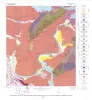
Rock-type Map of the Austin area, Plate I of RI 86 | 1976 | Garner, L.E. | Bureau of Economic Geology | |
|
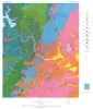
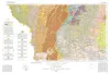
Geologic Atlas of Texas, Hobbs sheet | 1976 | Geologic map that depicts the surface geology of Gaines and Andrews Counties and parts of Yoakum, Terry, Dawson, Martin, Winkler, Ector, and Midland Counties, Texas. The 5-page booklet indicates geologic formations, abbreviations, and ages. |
Barnes, V.E., Eifler, G.K., Reeves, C.C., Kottlowski, F.E., Norman, D.M., Sherrod, C.H., Hansen, J.J. | Bureau of Economic Geology |
|
Shoreline changes on Matagorda Island and San Jose Island (Pass Cavallo to Aransas Pass) -- an analysis of historical changes of the Texas Gulf shoreline | 1976 | Historical monitoring along Matagorda Island and San Jose Island records the nature and magnitude of changes in position of the shoreline and vegetation line and provides insight into the factors affecting those changes. |
Morton, R.A., Pieper, M.J. | Bureau of Economic Geology |

|
Regional Tertiary cross sections -- Texas Gulf coast | 1976 | The Bureau of Economic Geology has been conducting regional studies of the Frio Formation along the Texas Gulf Coast to evaluate potential geothermal energy from deep, geopressured sandstone reservoirs (Bebout, Dorfman, and Agagu, 1975; Bebout, Agagu, and Dorfman, 1975). |
Bebout, D.G., Luttrell, P.E., Seo, J.H. | Bureau of Economic Geology |
|
Geology of the Kingsland Quadrangle, Llano and Burnet Counties, Texas | 1976 | Barnes, V.E. | Bureau of Economic Geology | |
|
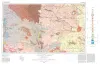
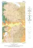
Geologic Atlas of Texas, Laredo sheet | 1976 | Geologic map that depicts the surface geology of parts of Webb, Duval, Jim Wells, Kleberg, Brooks, Jim Hogg, and Zapata Counties |
Barnes, V.E., Mobil Oil Co., Shell Oil Co., Humble Oil and Refining Co., Owens, Frith, Brewton, J.L., Tobin, Edward, Martin, R.G. | Bureau of Economic Geology |
|
Shoreline changes on Matagorda Peninsula (Brown Cedar Cut to Pass Cavallo) -- an analysis of historical changes of the Texas Gulf shoreline | 1976 | Historical monitoring along Matagorda Peninsula from Brown Cedar Cut to Pass Cavallo records the nature and magnitude of changes in position of the shoreline and vegetation line and provides insight into the factors affecting those changes. |
Morton, R.A., Pieper, M.J., McGowen, J.H. | Bureau of Economic Geology |
|
Geology of Midcities Area, Tarrant, Dallas, and Denton Counties, Texas | 1976 | Hendricks, Leo, Sampson, H.H. | Bureau of Economic Geology | |
|
Geothermal Resources of the Texas Gulf Coast: Environmental Concerns Arising from the Production and Disposal of Geothermal Waters | 1976 | Disposal and temporary surface storage of spent geothermal fluids and surface subsidence and faulting are the major environmental problems that could arise from geopressured geothermal water production. |
Gustavson, T.C., Kreitler, C.W. | Bureau of Economic Geology |