Bureau of Economic Geology Publications
| Title | Publication Year Sort ascending | Abstract | Author | Publisher | |
|---|---|---|---|---|---|
|
Texas Energy Reserves and Resources | 1978 | Contributing about 25 percent of all the energy ever produced in the United States, Texas has for 50 years led the nation in energy production. |
Fisher, W.L. | Bureau of Economic Geology |
|
Frio sandstone reservoirs -- in the deep subsurface along the Texas Gulf Coast; their potential for production of geopressured geothermal energy | 1978 | Tertiary strata of the Texas Gulf Coast comprise a number of terrigenous depositional wedges, some of which thicken abruptly at their downdip ends as a result of contemporaneous movement of growth faults and underlying salt. |
Bebout, D.G., Loucks, R.G., Gregory, A.R. | Bureau of Economic Geology |
|
National Energy Policy: A Continuing Assessment | 1978 | Bureau of Economic Geology | ||
|
Identification of surface faults by horizontal resistivity profiles, Texas coastal zone | 1978 | The land surface in the Texas Coastal Zone is interlaced with active and potentially active surface faults. They are subtle features which are difficult to identify until they have caused damage to manmade structures. To date (1978), significant damage has resulted. |
Kreitler, C.W., McKalips, D.G. | Bureau of Economic Geology |
|
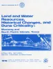
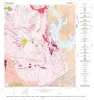
Land and water resources, historical changes, and dune criticality: Mustang and North Padre Islands, Texas | 1978 | Barrier islands along the Texas Coastal Zone are part of a complex and dynamic system represented by many distinct yet interrelated environments affected by a variety of resources, natural processes, climatic conditions, and human activities. |
White, W.A., Morton, R.A., Kerr, R.S., Kuenzi, W.D., Brogden, W.B. | Bureau of Economic Geology |
|
Geology of the Dunman Mountain Quadrangle, Llano, Burnet, and Blanco Counties, Texas | 1978 | Barnes, V.E. | Bureau of Economic Geology | |
|
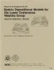
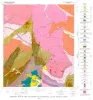
Epeiric depositional models for the Lower Cretaceous Washita Group, north-central Texas | 1978 | The Washita Group in North-Central Texas and southeastern Oklahoma consists of up to 114 m of intercalated shale, limestone, and sandstone that accumulated in the shallow, epicontinental sea of the East Texas Basin. |
Scott, R.W., Fee, D., Magee, R., Laali, Hooman | Bureau of Economic Geology |
|
Geology of the Cap Mountain Quadrangle, Llano County, Texas | 1978 | Barnes, V.E. | Bureau of Economic Geology | |
|
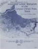
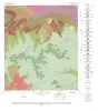
Land and water resources of the Corpus Christi area, Texas | 1978 | Land and water resources have been analyzed in the Corpus Christi area--Aransas, Nueces, Refugio, and San Patricio Counties along the central Texas coast. The city and port of Corpus Christi compose the largest metropolitan center in the area. |
Kier, R.S., White, W.A. | Bureau of Economic Geology |
|
Geology of the Howell Mountain quadrangle, Blanco and Llano Counties, Texas | 1978 | Barnes, V.E. | Bureau of Economic Geology |