Bureau of Economic Geology Publications
| Title | Publication Year Sort ascending | Abstract | Author | Publisher | |
|---|---|---|---|---|---|

|
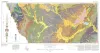
Geologic Atlas of Texas, Pecos sheet | 1976 | Geologic map that depicts the surface geology of Loving, Crane, and Ward Counties and parts of Ector, Midland, Upton, Pecos, Reeves, Crockett, and Winkler Counties, Texas. The 5-page booklet indicates geologic formations, abbreviations, and ages. |
Barnes, V.E., Eifler, G.K., Shell Oil Co., Cities Service Petroleum Co., Brown, J.B. | Bureau of Economic Geology |
|
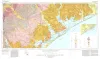
Geologic Atlas of Texas, Crystal City-Eagle Pass sheet | 1976 | Oversize color geologic map that depicts surface geology of Dimmit, LaSalle, and McMullen Counties and parts of Maverick, Zavala, Frio, Atascosa, Karnes, Wilson, Live Oak, Jim Wells, Duval, and Webb Counties, Texas. The 6-page booklet indicates geologic formations, abbreviations, and ages. |
Barnes, V.E., Humble Oil and Refining Co., Shell Oil Co., Amerada Petroleum Corp., Mobil Oil Co., Owens, Frith, Howeth, Ike, Brown, T.E. | Bureau of Economic Geology |
|
Geothermal resources, Frio Formation, middle Texas Gulf coast | 1975 | Knowledge of the regional sand distribution and its relationship to formation temperature and pressure is a preliminary step in evaluating the geothermal resources of the Frio Formation. |
Bebout, D.G., Agagu, O.K., Dorfman, M.H. | Bureau of Economic Geology |
|
Native bituminous materials in Texas | 1975 | Evans, T.J. | Bureau of Economic Geology | |
|
Determining the source of nitrate in ground water by nitrogen isotope studies | 1975 | Nitrogen isotope ratios of ammonium and nitrate ions from soil and water samples can be analyzed reproducibly with an experimental error of approximately +/-1 parts per thousand (ppt). Two isotopic ranges of soil nitrate are found in the soils of southern Runnels County, Texas. |
Kreitler, C.W. | Bureau of Economic Geology |
|
Land capability in the Lake Travis vicinity, Texas -- a practical guide for the use of geologic and engineering data | 1975 | The Lake Travis vicinity lies predominantly within a carbonate rock terrane and is the site of ongoing intensive residential development. |
Woodruff, C.M., Jr. | Bureau of Economic Geology |
|
The Mineral Industry of Texas in 1975 | 1975 | Hawkins, M.E., Evans, T.J. | Bureau of Economic Geology | |
|
Historical changes and related coastal processes, Gulf and mainland shorelines, Matagorda Bay area, Texas | 1975 | Change, both natural and man-induced, is a significant and defining element of the Coastal Zone. Man-induced change, by definition, can be controlled if desired. |
McGowen, J.H., Brewton, J.L. | Bureau of Economic Geology |
|
Land and Water Resources: Houston-Galveston Area Council | 1975 | The Houston-Galveston Area Council of Governments (HGAC) encompasses over 12,000 square miles of southeast Texas (fig. 1). |
St. Clair, A.E., Proctor, C.V., Jr., Fisher, W.L., Kreitler, C.W., McGowen, J.H. | Bureau of Economic Geology |
|
Geologic Atlas of Texas, Beeville-Bay City sheet (revised 1987) | 1975 | Geologic map that depicts the surface geology of Goliad, Refugio, and Calhoun Counties and parts of Karnes, De Witt, Victoria, Jackson, Matagorda, Aransas, San Patricio, Bee, and Live Oak Counties. The 4-page booklet indicates geologic formations, abbreviations, and ages. |
Barnes, V.E., Brown, T.E., Brewton, J.L., Aronow, Saul, Eargle, D.H., Morton, R.G., Maxson, M.J., Wyeth, J.C. | Bureau of Economic Geology |