Bureau of Economic Geology Publications
| Title | Publication Year Sort ascending | Abstract | Author | Publisher | |
|---|---|---|---|---|---|
|
The Mineral Industry of Texas in 1974 | 1974 | Hawkins, M.E., Girard, R.M. | Bureau of Economic Geology | |
|
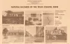
Natural hazards of the Texas coastal zone | 1974 | The Texas Coastal Zone is marked by diversity in geography, resources, climate, and industry. |
Brown, L.F., Jr., Morton, R.A., McGowen, J.H., Kreitler, C.W., Fisher, W.L. | Bureau of Economic Geology |
|
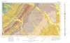
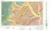
Geologic Atlas of Texas, Seguin sheet | 1974 | Geologic map that depicts the surface geology of Colorado, Lavaca, and Gonzales Counties, and parts of Hays, Caldwell, Bastrop, Fayette, Austin, Waller, Fort Bend, Wharton, Matagorda, Jackson, Victoria, De Witt, Karnes, Wilson, and Guadalupe Counties, Texas. |
Barnes, V.E., Humble Oil and Refining Co., Shell Oil Co., Mobil Oil Co., Proctor, C.V., Jr., Brown, T.E., Waechter, N.B., Aronow, Saul | Bureau of Economic Geology |
|
Depositional-Episodes: Their Relationship to the Quaternary Stratigraphic Framework in the Northwestern Portion of the Gulf Basin | 1974 | The stratigraphic record yields evidence that each episode of clastic silicate deposition has been of limited duration and that each has been preceded and followed by a significant hiatus. |
Frazier, D.E. | Bureau of Economic Geology |
|
Fluorspar in Texas | 1974 | Fluorspar is a basic raw material used in the chemical, metallurgical, and ceramic industries. This handbook describes the occurrence, grades, geology, uses, and prospects for development of fluorspar in Texas. |
McAnulty, W.N. | Bureau of Economic Geology |
|
Shoreline changes on Galveston Island (Bolivar Roads to San Luis Pass) -- an analysis of historical changes of the Texas Gulf shoreline | 1974 | Historical monitoring along Galveston Island records the type and magnitude of changes in position of the shoreline and vegetation line and provides insight into the factors affecting those changes. |
Morton, R.A. | Bureau of Economic Geology |
|
Bituminous coal in Texas | 1974 | Coal is found in six areas in Texas, including the large North-Central Texas field, a distinctive cannel coalfield in Webb County, and Late Cretaceous-age coals near Eagle Pass. |
Evans, T.J. | Bureau of Economic Geology |
|
Geologic Atlas of Texas, Austin sheet | 1974 | Geologic map that depicts the surface geology of Burleson, Lee, Washington, and Brazos Counties and parts of Burnet, Bell, Milam, Robertson, Madison, Grimes, Waller, Austin, Fayette, Bastrop, Caldwell, Hays, Travis, and Williamson Counties. |
Barnes, V.E., Shell Oil Co., Humble Oil and Refining Co., Mobil Oil Co., Proctor, C.V., Jr., Brown, T.E., McGowen, J.H., Waechter, N.B. | Bureau of Economic Geology |
|
A Numeric Code for Describing Rocks in Sedimentary Basins | 1974 | The purpose of this paper is to present a system of encoding rock data for multiple uses that include (1) mapping subsurface stratigraphy for economic exploration, (2) cataloging borings used in subsurface waste disposal, and (3) building a library of natural resource information. |
Wermund, E.G., Caughey, C.A. | Bureau of Economic Geology |
|
Potential geothermal resources of Texas | 1974 | Geothermal energy is rapidly becoming recognized, both in the United States and abroad, as a viable source of energy which can supplement fossil fuels for electric power generation. |
Dorfman, M.H., Kehle, R.O. | Bureau of Economic Geology |