Publications by Garner, L.E.
| Title | Publication Year Sort ascending | Abstract | Author | Series | Publisher | |
|---|---|---|---|---|---|---|
|
Limestone Resources of Texas | 1994 | Garner, L.E. | Mineral Resource Circular | Bureau of Economic Geology | |
|
The dimension stone industry of Texas | 1992 | Garner, L.E. | Mineral Resource Circular | Bureau of Economic Geology | |
|
The Guadalupe - Lavaca - San Antonio - Nueces River basins regional study: San Antonio East - Llano East sheets | 1985 | Wermund, E.G., Gustavson, T.C., Garner, L.E., Morton, R.A., Woodruff, C.M., Jr., Macpherson, G.L., McKinney, L., Nilsson, J. | River Basins Regional Studies | Bureau of Economic Geology | |
|
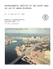
Environmental geology of the Yegua - Jackson lignite belt, southeast Texas | 1982 | Environmental geologic maps of the Texas lignite belt were prepared in response to renewed production of lignite in Texas and enactment of Federal and State laws governing coal and lignite surface mining. |
Jackson, M.L.W., Garner, L.E., Sharpe, R.D. | Report of Investigations | Bureau of Economic Geology |
|
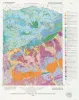
Mineral resources of Texas | 1979 | The Mineral Resources of Texas map is designed to illustrate the historical and current (as of 1976) distribution of industrial mineral occurrences and production sites in Texas. |
Garner, L.E., St. Clair, A.E., Evans, T.J. | Energy and Mineral Resource Maps | Bureau of Economic Geology |
|
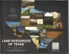
Land resources of Texas | 1977 | Texas is endowed with an enormous variety of natural land resources that vary from the humid forest lands of East Texas to the vast desert lands of Trans-Pecos, from the swamps and marshes of the Texas Coastal Zone to the arid plains of the Panhandle, and from the rich farmland of Central Texas t |
Kier, R.S., Garner, L.E., Brown, L.F., Jr., University of Texas at Austin, Bureau of Economic Geology | Selected Reports | Bureau of Economic Geology |
|
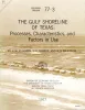
The Gulf shoreline of Texas: processes, characteristics, and factors in use | 1977 | The State of Texas has about 367 miles of open Gulf shoreline, most of it typified by rather broad, sandy beaches and a comparatively mild climate that permits almost year-round use of this recreational resource. All but about 87 miles of the Gulf beach is accessible to the general public. |
McGowen, J.H., Garner, L.E., Wilkinson, B.H. | Geological Circular | Bureau of Economic Geology |
|
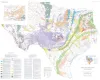
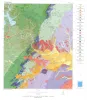
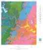
Environmental geology of the Austin area: an aid to urban planning | 1976 | The area described in this report comprises 712 square miles centered on the City of Austin. The area extends north almost to Round Rock, south to the vicinity of Buda, east to just beyond Manor, and west to about 5 miles west of Oak Hill. |
Garner, L.E., Young, Keith | Report of Investigations | Bureau of Economic Geology |
|
Geologic Map of the Austin Area, Color map, Plate VII of RI 86 | 1976 | Garner, L.E. | Miscellaneous Map | Bureau of Economic Geology | |
|
Rock-type Map of the Austin area, Plate I of RI 86 | 1976 | Garner, L.E. | Miscellaneous Map | Bureau of Economic Geology |