Bureau of Economic Geology Publications
| Title | Publication Year Sort ascending | Abstract | Author | Publisher | |
|---|---|---|---|---|---|

|
Coal Gasification and Liquefaction | 1979 | van Rensburg, W.C.J. | Bureau of Economic Geology | |
|
The Future Utilization of Texas Lignites: A Review | 1979 | van Rensburg, W.C.J. | Bureau of Economic Geology | |
|
Geology and geohydrology of the Palo Duro Basin, Texas panhandle -- a report on the progress of nuclear waste isolation feasibility studies (1978) | 1979 | Integrated, detailed, and comprehensive study of the physical stratigraphy, tectonic history, hydrogeology, geomorphology, and resource potential of the Palo Duro and Dalhart Basins, Texas Panhandle, is part of a national evaluation of ancient salt basins as potential sites for isolation and mana |
Dutton, S.P., Finley, R.J., Galloway, W.E., Gustavson, T.C., Handford, C.R., Presley, M.W. | Bureau of Economic Geology |
|
Land resource overview of the Capital Area Planning Council Region, Texas -- a nontechnical guide | 1979 | Bastrop, Blanco, Burnet, Caldwell, Fayette, Hays, Lee, Llano, Travis, and Williamson Counties make up the Capital Area Planning Council (CAPCO) region in Central Texas (fig. 1). The region covers 8,427 square miles (21,826 km2) and includes land of great physical diversity. |
Woodruff, C.M., Jr. | Bureau of Economic Geology |
|
Geochemistry of bottom sediments -- Matagorda Bay system, Texas | 1979 | Approximately 800 sediment samples from stream beds and bay bottoms of water bodies that compose the Matagorda Bay system were collected and analyzed. Shell-sand-mud ratios and total organic carbon content were determined, and 20 trace elements were detected. |
McGowen, J.H., Byrne, J.R., Wilkinson, B.H. | Bureau of Economic Geology |

|
Landsat analysis of the Texas coastal zone | 1979 | Mapping based on Landsat imagery was initiated along the Texas coast for four test sites selected for contrasting vegetation, environmental geology, and levels of economic development. |
Finley, R.J. | Bureau of Economic Geology |
|
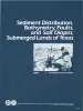
Sediment distribution, bathymetry, faults, and salt diapirs, submerged lands of Texas | 1979 | The State-owned submerged lands of Texas encompass nearly 6,000 square miles (15,540 km²) and extend from Mexico to Louisiana. The area includes the bays, estuaries, and lagoons, as well as the inner continental shelf 10.3 miles (16.6 km) seaward of the Gulf shoreline (fig. 1). |
McGowen, J.H., Morton, R.A. | Bureau of Economic Geology |
|
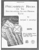
Precambrian rocks of the southeastern Llano region, Texas | 1979 | Precambrian sedimentary rocks and associated mafic and silicic igneous rocks in Central Texas underwent a single episode of regional metamorphism about 1,050 million years (m.y.) ago. |
McGehee, R.V. | Bureau of Economic Geology |
|
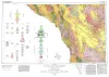
Geologic Atlas of Texas, Marfa sheet | 1979 | Geologic map that depicts surface geology of parts of Hudspeth, Culberson, Jeff Davis, and Presidio Counties, Texas. The 12-page explanatory booklet indicates geologic formations, abbreviations, and ages. |
Barnes, V.E., Twiss, P.C., Continental Oil Co., Cities Service Petroleum Co., Geophoto Services Inc., Norman, D.M., Sherrod, C.H., Pearson, B.T. | Bureau of Economic Geology |
|
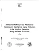
Sandstone distribution and potential for geopressured geothermal energy production in the Vicksburg Formation along the Texas Gulf coast | 1979 | Potential geopressured geothermal reservoirs in the Vicksburg Formation are limited to Hidalgo County along the Lower Texas Gulf Coast. |
Loucks, R.G. | Bureau of Economic Geology |