Publication Details
Geolocation:
Get the Publication
$10.00
Abstract/Description:
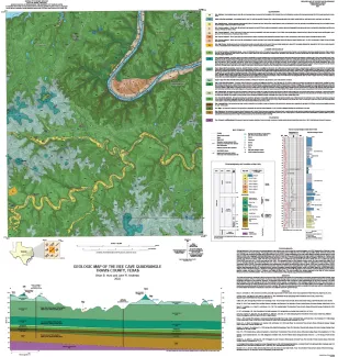
Geology illustrated on this map and accompanying geologic map database was revised using field, aerial-photograph, and LiDAR interpretations following a review of previous work on the area’s geology. The geologic map and unit descriptions were modified from the 1:24,000-scale by Collins (2016), which then became part of a 1:50,000-scale compilation geologic map by Woodruff and Collins (2019). Overall modifications in this map include slightly modified contacts based on newly obtained LiDAR, new mapping of submerged Quaternary units within the Colorado River, and modifications to the cross section and collar figures. Previous maps of the area include the 1:250,000-scale Austin Sheet (Proctor and others, 1974), the 1:125,000-scale geologic folio (Hill and Vaughan, 1902), and a 1:62,500-scale geologic map (Garner and others, 1976). The Bee Cave area lies west of a 1:24,000-scale map by Rodda and others. (1970), east of a 1:24,000-scale map by Collins (2002), and north of a 1:24,000-scale map by Kolb (1981). The topographic base and other features (roads, creeks, etc.) was created from digital files of the U.S. Geological Survey (The National Map) Bee Cave, Texas, 7.5 minute topographic quadrangle map. LiDAR was obtained from Texas Natural Resource Information System (TNRIS). Subsurface stratigraphic and hydrogeologic information was derived from Hunt and others, (2020) and Cockrell and others, (2020). Water level data for the multiport water well was obtained from Justin Camp of the Barton Springs/Edwards Aquifer Conservation District. Mapping and related activities were supported by the U.S. Geological Survey, National Cooperative Geologic Mapping Program, under STATEMAP award No. G21AC10838 (2021), Jeffrey G. Paine, Principal Investigator. GIS layers and digital cartography by Brian B. Hunt with support from John Andrews. Under the direction of Jason Suarez, graphics, design, and layout by Jana S. Robinson, and editing by Elyse Vane. This work benefited from studies supported by the State of Texas Advanced Resource Recovery (STARR) initiative. This map contains a GeMS database (http://ngmdb.usgs.gov/Info/standards/GeMS).