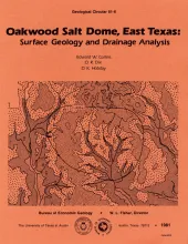
Oakwood Salt Dome in Leon and Freestone Counties, East Texas, is under consideration as a nuclear waste repository. The surficial geology above the dome provides information needed to evaluate the last stages of salt growth in Oakwood Dome and has a bearing on studies of ground-water flow patterns. The Claiborne Group has been uplifted, exposed, and eroded as a result of dome growth. The Carrizo, Reklaw, and Queen City Formations crop out over the dome. The Carrizo Formation comprises bedload- dominated alluvial deposits and is an important aquifer.
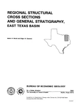
Jurassic, Cretaceous, and Tertiary sediments in the East Texas Basin have been structurally modified by movement of Middle Jurassic Louann Salt. Important structural elements in the basin include salt diapirs, deep salt anticlines and turtle-structure anticlines as well as prominent fault systems. This set of eight regional structural cross sections shows the general stratigraphy and structure of the basin and illustrates the effect of salt movement. Accompanying the cross sections is a brief discussion of the regional structure and stratigraphy.
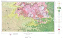
Geologic map that depicts the surface geology of Mason, Llano, and Gillespie Counties and parts of Menard, Kimble, San Saba, McCulloch, Edwards, Real, Kerr, Kendall, Blanco, Hays, Travis, Williamson, and Burnet Counties, Texas. The 15-page booklet indicates geologic formations, abbreviations, and ages.