Publications by McKalips, D.G.
| Title | Publication Year Sort ascending | Abstract | Author | Series | Publisher | |
|---|---|---|---|---|---|---|
|
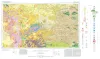
Geologic Atlas of Texas, Fort Stockton sheet (revised 1994) | 1982 | Geologic map that depicts the surface geology of parts of Jeff Davis, Reeves, Pecos, Terrell, Brewster, and Presidio Counties, Texas. The 9-page booklet indicates geologic formations, abbreviations, and ages. |
Barnes, V.E., Humboldt Oil and Refining Co., Mobil Oil Co., Geophoto Services Inc., Cities Service Petroleum Co., Anderson, J.E., Brown, J.B., Gries, J.C. | Geologic Atlas of Texas | Bureau of Economic Geology |
|
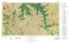
Geologic Atlas of Texas, Sonora sheet | 1981 | Geologic map that depicts the surface geology of Sutton County and parts of Terrell, Crockett, Val Verde, Edwards, Kimble, Menard, Schleicher, and Pecos Counties. |
Barnes, V.E., McKalips, D.G., Cities Service Petroleum Co., Geophoto Services Inc., Stump, R.W., Brown, J.B., Pearson, B.T., Volkmann, R.G. | Geologic Atlas of Texas | Bureau of Economic Geology |
|
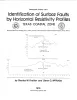
Identification of surface faults by horizontal resistivity profiles, Texas coastal zone | 1978 | The land surface in the Texas Coastal Zone is interlaced with active and potentially active surface faults. They are subtle features which are difficult to identify until they have caused damage to manmade structures. To date (1978), significant damage has resulted. |
Kreitler, C.W., McKalips, D.G. | Geological Circular | Bureau of Economic Geology |
|
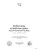
Hydrogeology of Gulf coast aquifers, Houston-Galveston area, Texas | 1977 | Aquifers in the Houston-Galveston area are composed principally of fluvial-deltaic sediments. The Alta Loma Sand is a complexly faulted, high-sand-percent unit that represents a seaward progression of fluvial, delta-plain, and delta-front facies. |
Kreitler, C.W., Guevara, E.H., Granata, G.E., McKalips, D.G. | Geological Circular | Bureau of Economic Geology |