Publications by Geophoto Services Inc.
| Title | Publication Year Sort ascending | Abstract | Author | Series | Publisher | |
|---|---|---|---|---|---|---|
|
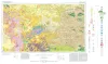
Geologic Atlas of Texas, Fort Stockton sheet (revised 1994) | 1982 | Geologic map that depicts the surface geology of parts of Jeff Davis, Reeves, Pecos, Terrell, Brewster, and Presidio Counties, Texas. The 9-page booklet indicates geologic formations, abbreviations, and ages. |
Barnes, V.E., Humboldt Oil and Refining Co., Mobil Oil Co., Geophoto Services Inc., Cities Service Petroleum Co., Anderson, J.E., Brown, J.B., Gries, J.C. | Geologic Atlas of Texas | Bureau of Economic Geology |
|
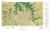
Geologic Atlas of Texas, Sonora sheet | 1981 | Geologic map that depicts the surface geology of Sutton County and parts of Terrell, Crockett, Val Verde, Edwards, Kimble, Menard, Schleicher, and Pecos Counties. |
Barnes, V.E., McKalips, D.G., Cities Service Petroleum Co., Geophoto Services Inc., Stump, R.W., Brown, J.B., Pearson, B.T., Volkmann, R.G. | Geologic Atlas of Texas | Bureau of Economic Geology |
| |
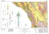
Geologic Atlas of Texas, Emory Peak-Presidio sheet | 1979 | Geologic map that depicts the surface geology of parts of Presidio, Brewster, and Terrell Counties, Texas. The 14-page booklet indicates geologic formations, abbreviations, and ages. |
Barnes, V.E., Geophoto Services Inc., Cities Service Petroleum Co., Mobil Oil Co., Cepeda, N.J., Daugherty, F.W., Brown, J.B., Norman, D.B. | Geologic Atlas of Texas | Bureau of Economic Geology |
|
Geologic Atlas of Texas, Marfa sheet | 1979 | Geologic map that depicts surface geology of parts of Hudspeth, Culberson, Jeff Davis, and Presidio Counties, Texas. The 12-page explanatory booklet indicates geologic formations, abbreviations, and ages. |
Barnes, V.E., Twiss, P.C., Continental Oil Co., Cities Service Petroleum Co., Geophoto Services Inc., Norman, D.M., Sherrod, C.H., Pearson, B.T. | Geologic Atlas of Texas | Bureau of Economic Geology |