Bureau of Economic Geology Publications
| Title | Publication Year Sort ascending | Abstract | Author | Publisher | |
|---|---|---|---|---|---|
|
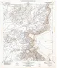
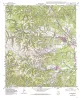
Geologic map of the Whiterock Hills Quadrangle, Texas | 1996 | Collins, E.W. | Bureau of Economic Geology | |
|
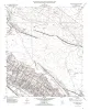
Geologic map of the Fort Hancock NW quadrangle, Texas | 1996 | Collins, E.W. | Bureau of Economic Geology | |
|
Boonsville 3-D Seismic Data Set | 1996 | Hardage, B.A., Simmons, J.L., Jr., Lancaster, D.E., Elphick, R.Y., Edson, R.D., Carr, D.L., Pendleton, V.M. | Bureau of Economic Geology | |
|
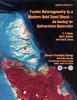
Facies Heterogeneity in a Modern Ooid Sand Shoal--An Analog for Hydrocarbon Reservoirs | 1996 | The ooid-sand shoals of the Joulters Cays area of Great Bahama Bank were chosen for detailed sedimentologic study to investigate patterns of internal heterogeneity within a modern carbonate sand deposit and to develop criteria for predicting the lateral extent of porous and permeable carbonate gr |
Major, R.P., Bebout, D.G., Harris, P.M. | Bureau of Economic Geology |
|
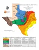
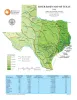
Physiographic Map of Texas | 1996 | Wermund, E.G. | Bureau of Economic Geology | |
|
River Basin Map of Texas | 1996 | Wermund, E.G. | Bureau of Economic Geology | |
|
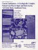
Canyon sandstones -- a geologically complex natural gas play in slope and basin facies, Val Verde basin, southwest Texas | 1995 | Canyon sandstones form a prolific low-permeability gas play in the Val Verde Basin of southwest Texas. Exploration and development activity is at a high level, but little published information on Canyon geology is available. |
Hamlin, H.S., Clift, S.J., Dutton, S.P., Hentz, T.F., Laubach, S.E. | Bureau of Economic Geology |
|
Geologic map of the Ranger Creek Quadrangle, Texas | 1995 | Collins, E.W. | Bureau of Economic Geology | |
|
Geologic map of the Waring quadrangle, Texas | 1995 | Collins, E.W. | Bureau of Economic Geology | |
|
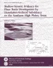
Shallow-seismic evidence for playa basin development by dissolution-induced subsidence on the southern High Plains, Texas | 1995 | The origin of thousands of playa basins on the Southern High Plains of Texas and New Mexico has been attributed to eolian deflation, evaporite or carbonate dissolution and subsidence, piping, or animal activity. |
Paine, J.G. | Bureau of Economic Geology |