Bureau of Economic Geology Publications
| Title | Publication Year Sort ascending | Abstract | Author | Publisher | |
|---|---|---|---|---|---|
|
Production Optimization of Tide-Dominated Deltaic Reservoirs of the Lower Misoa Formation (Lower Eocene) LL-652 Area, Lagunillas Field, Lake Maracaibo, Venezuela | 1995 | Structurally complex, heterogeneous, tide-dominated deltaic reservoirs in the Lower Misoa Formation (lower Eocene C members) in the LL-652 area of Lagunillas field in the Maracaibo Basin, Venezuela, have produced 166 million stock-tank barrels (MMSTB) of oil but have a low recovery efficiency of |
Ambrose, W.A., Ferrer, E.R., Dutton, S.P., Wang, F.P., Padron, A., Carrasquel, W., Yeh, J.S., Tyler, Noel | Bureau of Economic Geology |
|
On Solid Ground: Memoirs of a Texas Geologist | 1995 | In his memoirs, Virgil Barnes recounts highlights of his life and career in entertaining detail: his childhood in Washington; his worldwide travels in search of tektites, accompanied by his wife, Milla; and his geological mapping and other research during his 58 years at the Bureau of Economic Ge |
Barnes, V.E. | Bureau of Economic Geology |
|
Controls on reservoir heterogeneity in Permian shallow-water-platform carbonate reservoirs, Permian Basin: implications for improved recovery | 1995 | Shallow-water-platform carbonate reservoirs of Permian age have accounted for more than half of the oil production in the Permian Basin, one of the largest oil-producing regions in the United States. |
Ruppel, S.C., Kerans, Charles, Major, R.P., Holtz, M.H. | Bureau of Economic Geology |
|
Geologic map of the Fort Bliss SE Quadrangle, Texas | 1995 | Collins, E.W. | Bureau of Economic Geology | |
|
Geologic map of the Ysleta quadrangle, Texas | 1995 | Collins, E.W., Raney, J.A. | Bureau of Economic Geology | |
|
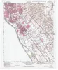
Identification and assessment of remaining oil resources in the Frio fluvial-deltaic sandstone play, south Texas | 1995 | The Frio Fluvial-Deltaic Sandstone (Vicksburg Fault Zone) play of South Texas has produced nearly 1 billion barrels (Bbbl) of oil since field development began in the 1940's. |
Holtz, M.H., McRae, L.E. | Bureau of Economic Geology |

|
Naturally Occurring Radioactive Materials (NORM) in Produced Water and Scale from Texas Oil, Gas, and Geothermal Wells | 1995 | Water produced from oil, gas, and geothermal reservoirs contains natural radioactivity that ranges from background levels to levels found in uranium mill tailings. |
Fisher, R.S. | Bureau of Economic Geology |
|
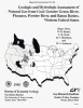
Geologic and Hydrologic Assessment of Natural Gas from Coal: Greater Green River, Piceance, Powder River, and Raton Basins, Western United States | 1995 | Five coal basins in the Rocky Mountain Foreland of the western United States--San Juan, Greater Green River, Piceance, Powder River, and Raton--contain, by virtue of their tremendous coal tonnage, 522 Tcf (14.7 Tm3) coalbed gas resources, or 77 percent of the nation's total of 675 Tcf (19.1 |
Tyler, Roger, Kaiser, W.R., Scott, A.R., Hamilton, D.S., Ambrose, W.A. | Bureau of Economic Geology |
|
Seismic analysis of the Duval County Ranch area, south Texas: assessment of exploration potential of the Wilcox, Queen City, and Jackson-Yegua plays | 1995 | Potential for commercial hydrocarbon accumulations in Eocene and older strata of the Duval County Ranch in South Texas was assessed using seismic data. Three seismic facies are recognized and tied to well control. |
Fiduk, J.C., Hamilton, D.S. | Bureau of Economic Geology |
|
Geologic map of the Medina Lake Quadrangle, Texas | 1995 | Collins, E.W. | Bureau of Economic Geology |