Bureau of Economic Geology Publications
| Title | Publication Year Sort ascending | Abstract | Author | Publisher | |
|---|---|---|---|---|---|
|
Origin and development of playa basins, sources of recharge to the Ogallala aquifer, southern High Plains, Texas and New Mexico | 1995 | More than 20,000 playa basins have formed on the Southern High Plains of Texas and New Mexico. |
Gustavson, T.C., Holliday, V.T., Hovorka, S.D. | Bureau of Economic Geology |
|
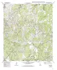
Geologic map of the Helms West Well Quadrangle, Texas | 1995 | Collins, E.W., Raney, J.A. | Bureau of Economic Geology | |
|
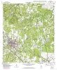
Geologic map of the Pipe Creek Quadrangle, Texas | 1995 | Collins, E.W. | Bureau of Economic Geology | |
|
Chert reservoir development in the Devonian Thirtyone Formation: Three Bar field, West Texas | 1995 | Chert reservoirs of the Lower Devonian Thirtyone Formation represent a substantial part of the hydrocarbon resource in the Permian Basin. More than 700 million barrels of oil has been produced from these rocks, and an equivalent amount of mobile oil remains. |
Ruppel, S.C., Hovorka, S.D. | Bureau of Economic Geology |
|
Geologic map of the Bergheim quadrangle, Texas | 1994 | Collins, E.W. | Bureau of Economic Geology | |
|
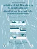
Initiation of Salt Diapirism by Regional Extension: Global Setting, Structural Style, and Mechanical Models | 1994 | Initiation of diapirs is one of the least understood aspects of salt tectonics. Sedimentary differential loading and erosion are both effective, but not universal, causes of diapir initiation. |
Jackson, M.P.A., Vendeville, B.C. | Bureau of Economic Geology |
|
Geologic map of the Boerne quadrangle, Texas | 1994 | Collins, E.W. | Bureau of Economic Geology | |
|
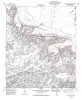
Geologic map of the Diablo Canyon West quadrangle, Texas | 1994 | Collins, E.W., Raney, J.A. | Bureau of Economic Geology | |
|
Depositional and diagenetic facies patterns and reservoir development in Silurian and Devonian rocks of the Permian basin | 1994 | Silurian and Devonian carbonate and chert rocks in the Permian Basin constitute a prolific hydrocarbon-bearing succession in West Texas and New Mexico. |
Ruppel, S.C., Holtz, M.H. | Bureau of Economic Geology |
|
Limestone Resources of Texas | 1994 | Garner, L.E. | Bureau of Economic Geology |