Bureau of Economic Geology Publications
| Title | Publication Year Sort ascending | Abstract | Author | Publisher | |
|---|---|---|---|---|---|
|
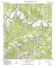
Geologic map of the Waring quadrangle, Texas | 1995 | Collins, E.W. | Bureau of Economic Geology | |
|
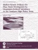
Shallow-seismic evidence for playa basin development by dissolution-induced subsidence on the southern High Plains, Texas | 1995 | The origin of thousands of playa basins on the Southern High Plains of Texas and New Mexico has been attributed to eolian deflation, evaporite or carbonate dissolution and subsidence, piping, or animal activity. |
Paine, J.G. | Bureau of Economic Geology |
|
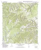
Geologic map of the Turkey Knob quadrangle, Texas | 1995 | Collins, E.W. | Bureau of Economic Geology | |
|
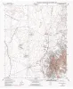
Geologic map of the Nations East Well quadrangle, Texas | 1995 | Collins, E.W. | Bureau of Economic Geology | |
|
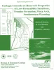
Geologic Controls on Reservoir Properties of Low-Permeability Sandstone, Frontier Formation, Moxa Arch, Southwestern Wyoming | 1995 | Authors of this report summarize the results of integrated geologic characterization of the Frontier Formation along the Moxa Arch in southwestern Wyoming in four major areas of study: (1) stratigraphic and depositional systems, (2) diagenesis of reservoir sandstones, (3) disttribution of natural |
Dutton, S.P., Hamlin, H.S., Laubach, S.E. | Bureau of Economic Geology |
|
Geologic map of the Nations South Well quadrangle, Texas | 1995 | Collins, E.W. | Bureau of Economic Geology | |
|
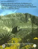
Sequence hierarchy and facies architecture of a carbonate-ramp system: San Andres Formation of Algerita Escarpment and western Guadalupe Mountains, West Texas and New Mexico | 1995 | This study offers a high-frequency sequence stratigraphic model of carbonate-ramp strata of the San Andres Formation. |
Kerans, Charles, Fitchen, W.M. | Bureau of Economic Geology |
|
Geologic map of the Clint quadrangle, Texas | 1995 | Collins, E.W., Raney, J.A. | Bureau of Economic Geology | |
|
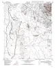
Quaternary evolution of playa lakes on the southern High Plains -- a case study from the Amarillo area, Texas | 1995 | This report documents the stratigraphy beneath playa lakes and associated lake-margin, playa-basin, and upland settings. |
Hovorka, S.D. | Bureau of Economic Geology |
|
Geologic map of the Clint NE quadrangle, Texas | 1995 | Collins, E.W., Raney, J.A. | Bureau of Economic Geology |