Publication Search

Bureau of Economic Geology Publications

Title Publication Year Sort ascending Abstract Author Publisher
Playas and recharge of the Ogallala aquifer on the southern High Plains of Texas -- an examination using numerical techniques Playas and recharge of the Ogallala aquifer on the southern High Plains of Texas -- an examination using numerical techniques 1997

This study used a numerical model to examine the playa-focused recharge theory by comparing it with the spatially uniform approach and with a zonal approach.

Mullican, W.F., Johns, N.D., Fryar, A.E. Bureau of Economic Geology
Geologic map of the Tarpley Quadrangle, Texas Geologic map of the Tarpley Quadrangle, Texas 1997 Collins, E.W. Bureau of Economic Geology
Geologic map of the Georgetown quadrangle, Texas Geologic map of the Georgetown quadrangle, Texas 1997 Collins, E.W. Bureau of Economic Geology
Spatial variability in unsaturated flow beneath playa and adjacent interplaya settings and implications for contaminant transport, southern High Plains, Texas Spatial variability in unsaturated flow beneath playa and adjacent interplaya settings and implications for contaminant transport, southern High Plains, Texas 1997

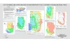
Analysis of spatial variability in unsaturated flow is critical to evaluating contaminant transport in areas of focused or preferential flow. This study examined spatial variability at a variety of scales from focused flow through playas to preferential flow in macropores.

Scanlon, B.R., Goldsmith, R.S., Mullican, W.F. Bureau of Economic Geology
Geologic map of the Texas Mountain quadrangle, Texas Geologic map of the Texas Mountain quadrangle, Texas 1997 Collins, E.W. Bureau of Economic Geology
The Application of a Coalbed Methane Producibility Model in Defining Coalbed Methane Exploration Fairways and Sweet Spots: Examples from the San Juan, Sand Wash, and Piceance Basins The Application of a Coalbed Methane Producibility Model in Defining Coalbed Methane Exploration Fairways and Sweet Spots: Examples from the San Juan, Sand Wash, and Piceance Basins 1997

This report applies a basin-scale coalbed methane producibility model in defining fairways and sweet spots in three coal basins in the United States.

Tyler, Roger, Scott, A.R., Kaiser, W.R., McMurry, R.G. Bureau of Economic Geology
Geologic map of the Timber Creek Quadrangle, Texas Geologic map of the Timber Creek Quadrangle, Texas 1997 Collins, E.W. Bureau of Economic Geology
Quaternary faults within intermontane basins of northwest Trans-Pecos Texas and Chihuahua, Mexico Quaternary faults within intermontane basins of northwest Trans-Pecos Texas and Chihuahua, Mexico 1997

This report details the occurrence, geometries, scarp morphology, and paleorupture histories of Quaternary faults of northwest Trans-Pecos Texas and northern Chihuahua, Mexico.

Collins, E.W., Raney, J.A. Bureau of Economic Geology
Tectonic Map of Texas Tectonic Map of Texas 1997 University of Texas at Austin, Bureau of Economic Geology Bureau of Economic Geology
Geologic map of the Twin Hollow Quadrangle, Texas Geologic map of the Twin Hollow Quadrangle, Texas 1997 Collins, E.W. Bureau of Economic Geology