Bureau of Economic Geology Publications
| Title | Publication Year Sort ascending | Abstract | Author | Publisher | |
|---|---|---|---|---|---|

|
Electrical Imaging Catalog: Microresistivity Images and Core Photos from Fractured, Karsted, and Brecciated Carbonates | 1997 | Electrical images in boreholes are becoming increasingly important in interpreting the rock record. |
Hammes, Ursula | Bureau of Economic Geology |
|
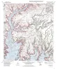
Geologic map of the Rough Canyon Quadrangle, Texas | 1997 | Collins, E.W. | Bureau of Economic Geology | |
|
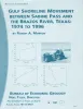
Gulf shoreline movement between Sabine Pass and the Brazos River, Texas: 1974 to 1996 | 1997 | Changes in shoreline position along the southeastern Texas Gulf coast between 1974 and 1996 were documented by conducting a kinematic real-time differential global positioning system (DGPS) field survey in 1996 and comparing that shoreline with other shorelines archived in a geographic informatio |
Morton, R.A. | Bureau of Economic Geology |
|
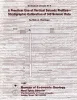
A Practical Use of Vertical Seismic Profiles-Stratigraphic Calibration of 3-D Seismic Data - Downloadable PDF | 1997 | Seismic interpreters must have a reliable methodology that allows them to (1) correlate seismic reflection events with well-log-defined sequence boundaries and (2) specify which seismic facies windows correspond to the rock facies intervals defined by well control. |
Hardage, B.A. | Bureau of Economic Geology |
|
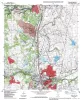
Geologic map of the Round Rock quadrangle, Texas | 1997 | Collins, E.W. | Bureau of Economic Geology | |
|
Principles of Onshore 3-D Seismic Design | 1997 | The basic geometry of an onshore three-dimensional (3-D) seismic recording grid is based on five parameters: source-station spacing, receiver-station spacing, source-line spacing. receiver-line spacing, and recording swath size. |
Hardage, B.A. | Bureau of Economic Geology |
|
Basin morphological controls on submarine-fan depositional trends: Spraberry Sandstone, Permian Basin, Texas | 1997 | The Leonardian Spraberry Formation is a major oil-producing formation of the Permian Basin, accounting for more than 700 million barrels of oil produced from heterogeneous submarine-fan reservoirs. |
Tyler, Noel, Gholston, J.C., Guevara, E.H. | Bureau of Economic Geology |
|
Geologic map of the Padre Canyon quadrangle, Texas | 1996 | Collins, E.W. | Bureau of Economic Geology | |

|
Combining P-Wave and S-Wave Seismic Data to Improve Prospect Evaluation | 1996 | This report presents three types of evidence documenting that the combination of P-wave and S-wave seismic data provides geologic insights that cannot be provided by conventional P-wave data alone. |
Hardage, B.A. | Bureau of Economic Geology |
|
Edwards aquifer ground-water resources: geologic controls on porosity development in platform carbonates, south Texas | 1996 | Focusing on the highly developed Edwards aquifer, which supplies water for a large area of south-central Texas, this report presents a three-dimensional model of the porosity distribution in the aquifer, which quantifies the spatial distribution of water resources and provides information that ca |
Hovorka, S.D., Dutton, A.R., Ruppel, S.C., Yeh, J.S. | Bureau of Economic Geology |