Publications by Barnes, V.E.
| Title | Publication Year Sort ascending | Abstract | Author | Series | Publisher | |
|---|---|---|---|---|---|---|
|
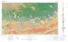
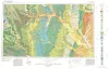
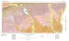
Geologic Atlas of Texas, San Antonio sheet (revised 1982) | 1974 | Geologic map that depicts the surface geology of Comal, Bandera, Bexar, and Medina Counties and parts of Real, Kerr, Kendall, Hays, Guadalupe, Wilson, Atascosa, Frio, Zavala, and Uvalde Counties, Texas. The 9-page booklet indicates geologic formations, abbreviations, and ages. |
Barnes, V.E., Shell Oil Co., Amerada Petroleum Corp., Brown, T.E., Waechter, N.B., Dillon, R.L. | Geologic Atlas of Texas | Bureau of Economic Geology |
|
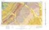
Geologic Atlas of Texas, Seguin sheet | 1974 | Geologic map that depicts the surface geology of Colorado, Lavaca, and Gonzales Counties, and parts of Hays, Caldwell, Bastrop, Fayette, Austin, Waller, Fort Bend, Wharton, Matagorda, Jackson, Victoria, De Witt, Karnes, Wilson, and Guadalupe Counties, Texas. |
Barnes, V.E., Humble Oil and Refining Co., Shell Oil Co., Mobil Oil Co., Proctor, C.V., Jr., Brown, T.E., Waechter, N.B., Aronow, Saul | Geologic Atlas of Texas | Bureau of Economic Geology |
|
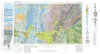
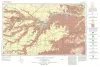
Geologic Atlas of Texas, Abilene sheet | 1972 | Geologic map that depicts the surface geology of Shackelford, Stephens, Palo Pinto, Callahan, and Eastland Counties and parts of Jones, Taylor, Runnels, Coleman, Brown, Comanche, Erath, Parker, and Hood Counties, Texas. |
Barnes, V.E., Brown, L.F., Jr., Goodson, J.L., Southern Minerals Corp., Humble Oil and Refining Co., Shell Oil Co., Harwood, P., Bloomer, R.R. | Geologic Atlas of Texas | Bureau of Economic Geology |
|
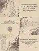
Geology of the Llano region and Austin area: field excursion | 1972 | This Guidebook represents an updating of Bureau of Economic Geology Guidebook No. 5, Field Excursion-Geology of Llano Region and Austin Area. It also represents a modification of Geology of the Llano Region and Austin Area, Texas, published by the Shreveport Geological Society in 1971. |
Barnes, V.E., Bell, W.C., Clabaugh, S.E., Cloud, P.E., Jr., McGehee, R.V., Rodda, P.U., Young, Keith | Guidebook | Bureau of Economic Geology |
|
Geologic Atlas of Texas, Dallas sheet (revised 1987) | 1972 | Geologic map that depicts surface geology of Tarrant, Dallas, Kaufman, Ellis, Johnson, Somervell, and Rockwall Counties and parts of Parker, Hood, Erath, Bosque, Hill, Navarro, Henderson, Van Zandt, and Hunt Counties, Texas. |
Barnes, V.E., Shell Oil Co., Humble Oil and Refining Co., Dallas Geological Society, Fort Worth Geological Society, McGowen, J.H., Proctor, C.V., Jr., Haenggi, W.T. | Geologic Atlas of Texas | Bureau of Economic Geology |
|
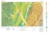
Geologic Atlas of Texas, Waco sheet | 1970 | Geologic maps that depicts the surface geology of McLennan, Limestone, and Falls Counties and parts of Bosque, Hill, Navarro, Freestone, Leon, Madison, Robertson, Milam, Bell, Lampasas, Coryell, and Hamilton Counties, Texas. |
Barnes, V.E., Humble Oil and Refining Co., Shell Oil Co., Mobil Oil Co., Proctor, C.V., Jr., McGowen, J.H., Haenggi, W.T., Hayward, O.T. | Geologic Atlas of Texas | Bureau of Economic Geology |
|
Geologic Atlas of Texas, Perryton sheet (revised 1993) | 1970 | Geologic map that depicts the surface geology of Hansford, Ochiltree, and Lipscomb Counties and parts of Moore, Hutchinson, Roberts, Hemphill, and Sherman Counties. |
Barnes, V.E., Eifler, G.K., Fay, R.O., Quackenbush, W.M., Horn, P.H., Hughes, C.D. | Geologic Atlas of Texas | Bureau of Economic Geology |
|
Geologic Atlas of Texas, Houston sheet (revised 1982) | 1968 | Geologic map that depicts the surface geology of Galveston and Chambers Counties and parts of Waller, Harris, Liberty, Jefferson, Orange, Brazoria, Matagorda, Wharton, and Fort Bend Counties. |
Barnes, V.E., Aronow, Saul, LeBlanc, R.J., Evans, F.G., Hinds, G.W., Holland, W.C., Van Siclen, D.C., Macon, J.W. | Geologic Atlas of Texas | Bureau of Economic Geology |
|
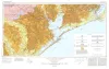
Geologic Atlas of Texas, Beaumont sheet (revised 1992) | 1968 | Geologic map that depicts the surface geology of Montgomery, San Jacinto, and Hardin Counties and parts of Madison, Trinity, Polk, Tyler, Jasper, Newton, Orange, Jefferson, Liberty, Harris, Waller, Grimes, Walker, and Robertson Counties. |
Barnes, V.E., Humble Oil and Refining Co., Shell Oil Co., Aronow, Saul, Shelby, C.A., Eargle, D.H., LeBlanc, R.J., Evans, F.G. | Geologic Atlas of Texas | Bureau of Economic Geology |
| |
Geologic Atlas of Texas, Van Horn-El Paso sheet (revised 1983) | 1968 | Geologic map that depicts the surface geology of El Paso County and parts of Hudspeth. Jeff Davis, and Culberson Counties, Texas. The 12-page booklet indicates geologic formations, abbreviations, and ages. Published in honor of E. |
Barnes, V.E., Shell Oil Co., Cities Service Petroleum Co., Dietrich, J.W., Owen, D.E., Shelby, C.A., Macon, J.W., Bridges, L.W. | Geologic Atlas of Texas | Bureau of Economic Geology |