Publications by Barnes, V.E.
| Title | Publication Year Sort ascending | Abstract | Author | Series | Publisher | |
|---|---|---|---|---|---|---|
|
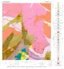
Geology of the Cap Mountain Quadrangle, Llano County, Texas | 1978 | Barnes, V.E. | Geologic Quadrangle Map | Bureau of Economic Geology | |
|
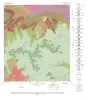
Geology of the Howell Mountain quadrangle, Blanco and Llano Counties, Texas | 1978 | Barnes, V.E. | Geologic Quadrangle Map | Bureau of Economic Geology | |
|
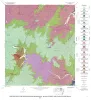
Geologic map of the Round Mountain quadrangle, Blanco, Burnet, and Llano counties. Texas | 1978 | Barnes, V.E. | Geologic Quadrangle Map | Bureau of Economic Geology | |
|
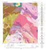
Geology of the Click Quadrangle, Llano and Blanco Counties, Texas | 1977 | Barnes, V.E. | Geologic Quadrangle Map | Bureau of Economic Geology | |
|
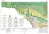
Geologic Atlas of Texas, Clovis sheet | 1977 | Geologic map that depicts the surface geology of Parmer and Castro Counties and parts of Deaf Smith, Randall, Bailey, Lamb, and Hale Counties. |
Barnes, V.E., Eifler, G.K., Reeves, C.C., Kottlowski, F.E., Quackenbush, W.M., Grant, W.D., Hughes, C.D. | Geologic Atlas of Texas | Bureau of Economic Geology |
|
Geologic Atlas of Texas, Del Rio sheet | 1977 | Geologic map that depicts surface geology of Kinney County and parts of Terrell, Val Verde, Edwards, Real, Uvalde, and Maverick Counties, Texas. |
Barnes, V.E., Waechter, N.B., Pinkley, G.R., Martin, R.G., Wyeth, J.C., Knupke, J.A., Sulik, J.F., Ellis, W.G. | Geologic Atlas of Texas | Bureau of Economic Geology |
|
The Moore Hollow Group of central Texas | 1977 | Middle and Upper Cambrian rocks and locally up to 90 feet of Lower Ordovician rocks in Central Texas, are here named the Moore Hollow Group. |
Barnes, V.E., Bell, W.C. | Report of Investigations | |
|
Geologic Atlas of Texas, McAllen-Brownsville sheet | 1976 | Geologic map that depicts surface geology of Starr, Hidalgo, Willacy, and Cameron Counties and parts of Zapata, Jim Hogg, Brooks, and Kenedy Counties. |
Barnes, V.E., Humble Oil and Refining Co., Shell Oil Co., Mobil Oil Co., Owens, Frith, Brewton, J.L., Aronow, Saul, Martin, R.G. | Geologic Atlas of Texas | Bureau of Economic Geology |
|
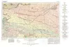
Geologic Atlas of Texas, Brownwood sheet | 1976 | Geologic map that depicts the surface geology of Mills County and parts of Runnels, Coleman, Brown, Comanche, Erath, Hamilton, Coryell, Lampasas, San Saba, McCulloch, Concho, and Menard Counties. The 21-page booklet indicates geologic formations, abbreviations, and ages. |
Kier, R.S., Harwood, P., Brown, L.F., Jr., Goodson, J.L., Barnes, V.E., Shell Oil Co., Humble Oil and Refining Co., Southern Minerals Corp. | Geologic Atlas of Texas | Bureau of Economic Geology |

|
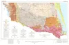
Geologic Atlas of Texas, Pecos sheet | 1976 | Geologic map that depicts the surface geology of Loving, Crane, and Ward Counties and parts of Ector, Midland, Upton, Pecos, Reeves, Crockett, and Winkler Counties, Texas. The 5-page booklet indicates geologic formations, abbreviations, and ages. |
Barnes, V.E., Eifler, G.K., Shell Oil Co., Cities Service Petroleum Co., Brown, J.B. | Geologic Atlas of Texas | Bureau of Economic Geology |