Publications by Barnes, V.E.
| Title | Publication Year Sort ascending | Abstract | Author | Series | Publisher | |
|---|---|---|---|---|---|---|
|
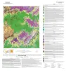
Geologic map of a Portion of the Southeastern Llano Uplift, Burnet, Llano, and Blanco Counties Texas | 2023 | Helper, M.A., Hunt, B.B., Barnes, V.E. | Open-File Map | Bureau of Economic Geology | |
|
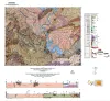
Geologic map of the Pedernales Falls, Johnson City, Howell Mountain, and Round Mountain quadrangles, Blanco County, Texas | 2021 | Hunt, B.B., Woodruff, C.M., Jr., Barnes, V.E. | Open-File Map | Bureau of Economic Geology | |
|
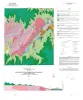
Geologic map of the Pedernales Falls quadrangle, Blanco County, Texas | 2019 | Woodruff, C.M., Jr., Costard, L., Barnes, V.E. | Open-File Map | Bureau of Economic Geology | |
|
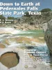
Down to Earth at Pedernales Falls State Park, Texas | 2003 | This nontechnical guidebook describes seven trails that visitors can walk within Pedernales (Spanish for the "flint" found in the park area) State Park, near Johnson City, in the Hill Country of Texas. |
Wermund, E.G., Barnes, V.E. | Down To Earth | Bureau of Economic Geology |
|
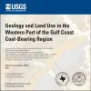
Geology and land use in the western part of the Gulf Coast coal-bearing region | 2002 | Warwick, P.D., Aubourg, C.E., Hook, R.W., SanFilipio, J.R., Barnes, V.E., Morrissey, E.A., Schultz, A.C., Karlsen, A.W. | Miscellaneous Map | Bureau of Economic Geology | |
|
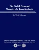
On Solid Ground: Memoirs of a Texas Geologist | 1995 | In his memoirs, Virgil Barnes recounts highlights of his life and career in entertaining detail: his childhood in Washington; his worldwide travels in search of tektites, accompanied by his wife, Milla; and his geological mapping and other research during his 58 years at the Bureau of Economic Ge |
Barnes, V.E. | Selected Reports | Bureau of Economic Geology |
|
Geologic map of Texas | 1992 | This large, 4-sheet geologic map displays more than 350 lithostratigraphic units ranging in age from Precambrian to Quaternary. |
University of Texas at Austin, Bureau of Economic Geology, Barnes, V.E., Hartmann, B., Scranton, D.F. | Thematic Maps | Bureau of Economic Geology |
|
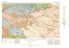
Geologic Atlas of Texas, Wichita Falls-Lawton sheet | 1987 | Geologic map that depicts the surface geology of Hardeman, Wilbarger, Wichita, Clay, Knox, Baylor, Archer, Haskell, Throckmorton, Young, and Foard Counties and part of Jack County, Texas. The 20-page booklet indicates geologic formations, abbreviations, and ages. |
Barnes, V.E., Hentz, T.F., Brown, L.F., Jr., Cleaves, A.W., Kier, R.S., McGowen, J.H., Parrish, W.C., Ramsey, J.W. | Geologic Atlas of Texas | Bureau of Economic Geology |
|
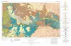
Geologic Atlas of Texas, Dalhart sheet | 1984 | Oversize color geologic map that depicts the surface geology of Dallam County and parts of Sherman, Moore, and Hartley Counties, Texas. The 6-page booklet indicates geologic formations, abbreviations, and ages. |
Barnes, V.E., Eifler, G.K., Fay, R.O., Trauger, F.D., Lappala E.G., Johnson, G.S., Hood, H.C., Stagges, D | Geologic Atlas of Texas | Bureau of Economic Geology |
|
Geologic Atlas of Texas, Tucumcari sheet | 1983 | Geologic map that depicts the surface geology of Oldham County and parts of Hartley, Deaf Smith, Moore, Potter, and Randall Counties. |
Barnes, V.E., Eifler, G.K., Trauger, F.D., Spiegel, Z., Hawley, J.W., Dillon, R.L., Kottlowski, F.E., Hood, C. | Geologic Atlas of Texas | Bureau of Economic Geology |