Publications by Shelby, C.A.
| Title | Publication Year Sort ascending | Abstract | Author | Series | Publisher | |
|---|---|---|---|---|---|---|
|
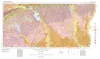
Geologic Atlas of Texas, Beaumont sheet (revised 1992) | 1968 | Geologic map that depicts the surface geology of Montgomery, San Jacinto, and Hardin Counties and parts of Madison, Trinity, Polk, Tyler, Jasper, Newton, Orange, Jefferson, Liberty, Harris, Waller, Grimes, Walker, and Robertson Counties. |
Barnes, V.E., Humble Oil and Refining Co., Shell Oil Co., Aronow, Saul, Shelby, C.A., Eargle, D.H., LeBlanc, R.J., Evans, F.G. | Geologic Atlas of Texas | Bureau of Economic Geology |
| |
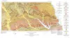
Geologic Atlas of Texas, Van Horn-El Paso sheet (revised 1983) | 1968 | Geologic map that depicts the surface geology of El Paso County and parts of Hudspeth. Jeff Davis, and Culberson Counties, Texas. The 12-page booklet indicates geologic formations, abbreviations, and ages. Published in honor of E. |
Barnes, V.E., Shell Oil Co., Cities Service Petroleum Co., Dietrich, J.W., Owen, D.E., Shelby, C.A., Macon, J.W., Bridges, L.W. | Geologic Atlas of Texas | Bureau of Economic Geology |
|
Geologic Atlas of Texas, Palestine sheet (revised 1993) | 1967 | Geologic map that depicts the surface geology of Nacogdoches, Shelby, San Augustine, Sabine, and Angelina Counties and parts of Anderson, Cherokee, Rusk, Newton, Jasper, Tyler, Polk, Trinity, Robertson, Madison, Leon, Freestone, and Panola Counties, Texas. |
Barnes, V.E., Humble Oil and Refining Co., Shell Oil Co., Pan American Petroleum Corp., Mobil Oil Co., Wright, A.C., McCallum, H.D., Wendlandt, E.A. | Geologic Atlas of Texas | Bureau of Economic Geology |
|
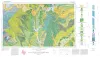
Geologic Atlas of Texas, Sherman sheet (revised 1991) | 1967 | Geologic map that depicts the surface geology of Montague, Cooke, Grayson, Wise, Denton, and Collin Counties and parts of Jack, Fannin, Hunt, and Clay Counties, Texas. The 16-page booklet indicates geologic formations, abbreviations, and ages. |
McGowen, J.H., Hentz, T.F., Owen, D.E., Pieper, M.K., Shelby, C.A., Barnes, V.E., Humble Oil and Refining Co., Pure Oil Co. | Geologic Atlas of Texas | Bureau of Economic Geology |
|
Heavy minerals in the Wellborn Formation, Lee and Burleson Counties, Texas | 1965 | At five places along the outcrop of the Wellborn Formation in Lee and Burleson counties, Texas, anomalously high gamma radiation is associated with concentrations of heavy minerals. The most abundant heavy minerals are ilmenite, magnetite, and zircon. |
Shelby, C.A. | Report of Investigations | Bureau of Economic Geology |
|
Rock and mineral resources of east Texas | 1965 | In the past 100 years, more than 100 names have been used to designate parts or all of the outcropping Midway and Wilcox rocks in the Gulf Coastal Plain; less than half of these names are used currently by Coastal Plain geologists, and the validity of some of the remaining named rock units has be |
Fisher, W.L., Chelf, C.R., Shelby, C.A., Garner, L.E., Owen, D.E., Shofield, D.A. | Report of Investigations | Bureau of Economic Geology |
|
Geologic Atlas of Texas, Tyler sheet | 1964 | Geologic map that depicts the surface geology of Rains, Wood, Upshur, Marion, Harrison, Smith, and Gregg Counties and parts of Camp, Cass, Panola, Rusk, Cherokee, Anderson, Henderson, Van Zandt, Hunt, Morris, Franklin, and Hopkins Counties, Texas. |
Barnes, V.E., Shell Oil Co., Humble Oil and Refining Co., Mobil Oil Co., Pan American Petroleum Corp., Eaton, R.W., Wright, A.C., McCallum, H.D. | Geologic Atlas of Texas | Bureau of Economic Geology |