Publications by Barnes, V.E.
| Title | Publication Year Sort ascending | Abstract | Author | Series | Publisher | |
|---|---|---|---|---|---|---|
|
Devonian - Mississippian transition in central Texas | 1957 | The Devonian-Mississippian transition outcrops of central Texas are here described summarily and assigned to a new stratigraphic unit, the Houy Formation. The beds included are mainly Upper Devonian, but partly Lower Mississippian. Locally a basal fraction may be Middle Devonian. |
Cloud, P.E., Jr., Barnes, V.E., Hass, W.H. | Report of Investigations | Bureau of Economic Geology |
|
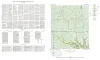
Geologic map of the Fall Prong Quadrangle, Kimble, Gillespie and Mason Counties, Texas | 1956 | Fall Prong quadrangle is in the marginal portion of the Edwards Plateau near the southeastern corner of the Llano region. Almost three-quarters of the quadrangle is within the Edwards Plateau, and the rest consists of valleys of the Llano basin cutting back into the plateau. |
Barnes, V.E. | Geologic Quadrangle Map | Bureau of Economic Geology |
|
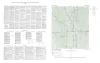
Lead deposits in the Upper Cambrian of central Texas | 1956 | The lead and zinc deposits in the Upper Cambrian rocks of central Texas are reviewed in the light of new detailed information. Included are analytical data for all deposits, detailed stratigraphic sections of the Cambrian rocks, and maps at a scale of 4 inches to the mile. |
Barnes, V.E. | Report of Investigations | Bureau of Economic Geology |
| |
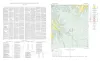
Map showing correlation of geologic, gravity, and magnetic observations, Blanco and Gillespie Counties, Texas | 1955 | Barnes, V.E., Romberg, Frederick, Anderson, W.A. | Miscellaneous Map | Bureau of Economic Geology | |
|
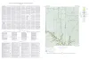
Geologic map of the Wendel Quadrangle, Kimble, Kerr, and Gillespie Counties, Texas | 1954 | Wendel quadrangle is entirely within the Edwards Plateau province and is situated southwest of the Llano region. |
Barnes, V.E. | Geologic Quadrangle Map | Bureau of Economic Geology |
|
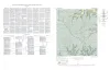
Geologic map of the Harper quadrangle, Gillespie County, Texas | 1954 | Harper quadrangle is in the Edwards Plateau province south of the Llano region. The plateau surface within the quadrangle is dissected by the Pedernales River and its tributaries in the southern part, and by Threadgill and Edwards Creeks in the northern part. |
Barnes, V.E. | Geologic Quadrangle Map | Bureau of Economic Geology |
|
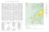
Geologic map of the Dry Branch quadrangle, Gillespie and Kerr Counties, Texas | 1954 | Dry Branch quadrangle is in the Edwards Plateau province southwest of the Llano region. |
Barnes, V.E. | Geologic Quadrangle Map | Bureau of Economic Geology |
|
Geologic map of the Klein Branch quadrangle, Gillespie and Kerr Counties, Texas | 1954 | Barnes, V.E. | Geologic Quadrangle Map | Bureau of Economic Geology | |
|
Geologic map of the Threadgill Creek quadrangle, Gillespie and Kerr Counties, Texas | 1954 | Barnes, V.E. | Geologic Quadrangle Map | Bureau of Economic Geology | |
|
Phosphorite in eastern Llano uplift of central Texas | 1954 | A deposit of phosphorite, estimated to be 11 feet thick, was found March 26, 1952, while the writer was mapping ancient sink fillings and collapse structures within the outcrop area of the Honeycut formation south of Marble Falls, Texas. |
Barnes, V.E. | Report of Investigations | Bureau of Economic Geology |