Publications by Barnes, V.E.
| Title | Publication Year Sort ascending | Abstract | Author | Series | Publisher | |
|---|---|---|---|---|---|---|
| |
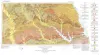
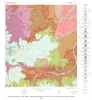
Geologic Atlas of Texas, Van Horn-El Paso sheet (revised 1983) | 1968 | Geologic map that depicts the surface geology of El Paso County and parts of Hudspeth. Jeff Davis, and Culberson Counties, Texas. The 12-page booklet indicates geologic formations, abbreviations, and ages. Published in honor of E. |
Barnes, V.E., Shell Oil Co., Cities Service Petroleum Co., Dietrich, J.W., Owen, D.E., Shelby, C.A., Macon, J.W., Bridges, L.W. | Geologic Atlas of Texas | Bureau of Economic Geology |
|
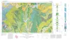
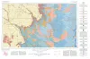
Geologic Atlas of Texas, Palestine sheet (revised 1993) | 1967 | Geologic map that depicts the surface geology of Nacogdoches, Shelby, San Augustine, Sabine, and Angelina Counties and parts of Anderson, Cherokee, Rusk, Newton, Jasper, Tyler, Polk, Trinity, Robertson, Madison, Leon, Freestone, and Panola Counties, Texas. |
Barnes, V.E., Humble Oil and Refining Co., Shell Oil Co., Pan American Petroleum Corp., Mobil Oil Co., Wright, A.C., McCallum, H.D., Wendlandt, E.A. | Geologic Atlas of Texas | Bureau of Economic Geology |
|
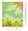
Geologic Atlas of Texas, Sherman sheet (revised 1991) | 1967 | Geologic map that depicts the surface geology of Montague, Cooke, Grayson, Wise, Denton, and Collin Counties and parts of Jack, Fannin, Hunt, and Clay Counties, Texas. The 16-page booklet indicates geologic formations, abbreviations, and ages. |
McGowen, J.H., Hentz, T.F., Owen, D.E., Pieper, M.K., Shelby, C.A., Barnes, V.E., Humble Oil and Refining Co., Pure Oil Co. | Geologic Atlas of Texas | Bureau of Economic Geology |
|
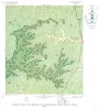
Geology of the Cave Creek School Quadrangle, Gillespie County, Texas | 1967 | Barnes, V.E. | Geologic Quadrangle Map | Bureau of Economic Geology | |
|
Geology of the Monument Hill Quadrangle, Blanco County, Texas | 1967 | Barnes, V.E. | Geologic Quadrangle Map | Bureau of Economic Geology | |
|
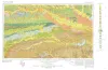
Geologic Atlas of Texas, Lubbock sheet (revised 1993) | 1967 | Geologic map that depicts surface geology of Crosby, Dickens, and King Counties and parts of Hale, Floyd, Motley, Cottle, King, Lubbock, Lynn, Garza, Kent, and Stonewall Counties. The Lubbock Sheet honors the late Dr. |
Eifler, G.K., Frye, J.C., Leonard, A.B., Hentz, T.F., Barnes, V.E. | Geologic Atlas of Texas | Bureau of Economic Geology |
|
Geology of the Yeager Creek Quadrangle, Blanco and Hays Counties, Texas | 1967 | Barnes, V.E. | Geologic Quadrangle Map | Bureau of Economic Geology | |
|
Geologic Atlas of Texas, Texarkana sheet (reprinted 1979 with base revised) | 1966 | Geologic map that depicts the surface geology of Lamar, Red River, Bowie, Delta, and Titus Counties and parts of Fannin, Hunt, Camp, Cass, Hopkins, Franklin, and Morris Counties, Texas. The 6-page booklet indicates geologic formations, abbreviations, and ages. |
Barnes, V.E., Humble Oil and Refining Co., Shell Oil Co., Pan American Petroleum Corp., Arkansas Geological and Conservation Commission, Oklahoma Geological Survey, McCallum, H.D., Wendlandt, E.A. | Geologic Atlas of Texas | Bureau of Economic Geology |
|
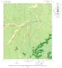
Geology of the Hye Quadrangle, Blanco, Gillespie, and Kendall Counties, Texas | 1965 | Hye quadrangle includes part of the southeastern Llano region and part of the eastern margin of the Edwards Plateau where most of the Plateau surface has been destroyed by erosion. |
Barnes, V.E. | Geologic Quadrangle Map | Bureau of Economic Geology |
|
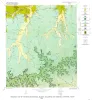
Geology of the Rocky Creek Quadrangle, Blanco and Gillespie Counties, Texas | 1965 | Barnes, V.E. | Geologic Quadrangle Map | Bureau of Economic Geology |