Publications by Barnes, V.E.
| Title | Publication Year Sort ascending | Abstract | Author | Series | Publisher | |
|---|---|---|---|---|---|---|
|
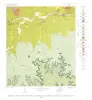
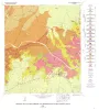
Geology of the Stonewall Quadrangle, Gillespie and Kendall Counties, Texas | 1965 | Stonewall quadrangle includes part of the southern margin of the Llano region and part of the eastern margin of the Edwards Plateau where most of the plateau suriace has been destroyed by erosion. |
Barnes, V.E. | Geologic Quadrangle Map | Bureau of Economic Geology |
|
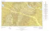
Geologic Atlas of Texas, Tyler sheet | 1964 | Geologic map that depicts the surface geology of Rains, Wood, Upshur, Marion, Harrison, Smith, and Gregg Counties and parts of Camp, Cass, Panola, Rusk, Cherokee, Anderson, Henderson, Van Zandt, Hunt, Morris, Franklin, and Hopkins Counties, Texas. |
Barnes, V.E., Shell Oil Co., Humble Oil and Refining Co., Mobil Oil Co., Pan American Petroleum Corp., Eaton, R.W., Wright, A.C., McCallum, H.D. | Geologic Atlas of Texas | Bureau of Economic Geology |
|
Potential low-grade iron ore and hydraulic-fracturing sand in Cambrian sandstones, northwestern Llano region, Texas | 1964 | The red upper unit of the Hickory Sandstone is a hematitic and goethitic sandstone containing a large reserve of potential low-grade iron ore. |
Barnes, V.E., Schofield, D.A. | Report of Investigations | Bureau of Economic Geology |
|
Field excursion - geology of Llano region and Austin area | 1963 | Barnes, V.E., Bell, W.C., Clabaugh, S.E., Cloud, P.E., Jr., Young, Keith, McGehee, R.V. | Guidebook | Bureau of Economic Geology | |
|
Correlation of Cambrian Rocks in Central Texas | 1963 | Barnes, V.E. | Miscellaneous Map | Bureau of Economic Geology | |
|
Geology of the Johnson City Quadrangle, Blanco County, Texas | 1963 | Barnes, V.E. | Geologic Quadrangle Map | Bureau of Economic Geology | |
|
Field excursion central Texas -- bentonites, uranium-bearing rocks, vermiculites | 1961 | The departure point of the Villa Capri Motor Hotel may be gone, but the geologic information within Guidebook Number 3 remains relevant to this day: "The four stops of this field trip are in the Upper Eocene (Jackson) and Oligocene volcanic ash and bentonite beds, which crop out about |
Folk, R.L., Hayes, M.O., Brown, T.E., Eargle, D.H., Weeks, A.D., Barnes, V.E., Clabaugh, S.E. | Guidebook | Bureau of Economic Geology |
|
Stratigraphy of the Pre-Simpson Paleozoic Subsurface Rocks of Texas and Southeast New Mexico | 1959 | Barnes, V.E., Cloud, P.E., Jr., Dixon, L.P., Polk, R.F., Jonas, E.C., Palmer, A.R., Tynan, E.J. | UT Publication | ||
|
Vermiculite in central Texas | 1959 | Vermiculite deposits in the Central Mineral region of Texas, chiefly in Precambrian metamorphic rocks, are situated in Llano County and adjacent parts of Mason, Gillespie, and Burnet counties with minor occurrences in Blanco and San Saba counties. |
Clabaugh, S.E., Barnes, V.E. | Report of Investigations | Bureau of Economic Geology |
|
Field excursion, eastern Llano region | 1958 | The first entry in the Guidebook Series details a field excursion to the Eastern Llano Region of Central Texas in 1958. Retrace the footsteps of Virgil Barnes and the other state geologists in attendance: Stop 1. Honeycut Bend |
Barnes, V.E. | Guidebook | Bureau of Economic Geology |