Publications by Barnes, V.E.
| Title | Publication Year Sort ascending | Abstract | Author | Series | Publisher | |
|---|---|---|---|---|---|---|
|
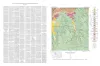
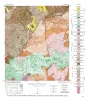
Geologic map of the Squaw Creek Quadrangle, Gillespie and Mason Counties, Texas | 1952 | The Squaw Creek quadrangle is partly within the Llano region and partly within the Edwards Plateau province. |
Barnes, V.E. | Geologic Quadrangle Map | Bureau of Economic Geology |
|
Geologic map of the Hilltop Quadrangle, Gillespie, Llano, and Mason Counties, Texas | 1952 | Barnes, V.E. | Geologic Quadrangle Map | Bureau of Economic Geology | |
|
Geologic Map of the Crabapple Creek Quadrangle Gillespie and Llano Counties, Texas | 1952 | Barnes, V.E. | Geologic Quadrangle Map | Bureau of Economic Geology | |
|
Geologic map of the Willow City quadrangle, Gillespie and Llano Counties, Texas | 1952 | Barnes, V.E. | Geologic Quadrangle Map | Bureau of Economic Geology | |
|
Geologic Map of the Blowout Quadrangle, Blanco, Gillespie, and Llano Counties, Texas | 1952 | Barnes, V.E. | Geologic Quadrangle Map | Bureau of Economic Geology | |
|
Geologic map of the Spring Creek Quadrangle, Gillespie County, Texas | 1952 | Barnes, V.E. | Geologic Quadrangle Map | Bureau of Economic Geology | |
|
Geologic map of the Live Oak Creek Quadrangle, Gillespie County, Texas | 1952 | Barnes, V.E. | Geologic Quadrangle Map | Bureau of Economic Geology | |
|
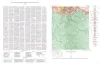
Geologic map of the Palo Alto Creek Quadrangle, Gillespie County, Texas | 1952 | Palo Alto Creek quadrangle is south of the Llano region and is in the marginal portion of the Edwards Plateau where much of the plateau surface has been destroyed by erosion. |
Barnes, V.E. | Geologic Quadrangle Map | Bureau of Economic Geology |
|
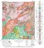
High purity Marble Falls limestone, Burnet County, Texas | 1952 | Chemical analyses show that a reef approximately 100 feet thick in the lower portionof the Marble Falls limestone near Marble Falls, Burnet County, Texas, is exceptionally pure. |
Barnes, V.E. | Report of Investigations | Bureau of Economic Geology |
|
Geologic map of the Gold Quadrangle, Gillespie County, Texas | 1952 | Barnes, V.E. | Geologic Quadrangle Map | Bureau of Economic Geology |